- Interstate 80
-
Interstate 80 
Longueur 4671 km (2902 mi) Ouverture 1957 Direction ouest / est Extrémité ouest  US 101 à San Francisco
Intersections  I-5 à Sacramento
 I-15 à Salt Lake City
 I-25 à Cheyenne (Wyoming)
 I-35 près de Des Moines (Iowa)
 I-55 près de Joliet (Illinois)
 I-65 à Gary (Indiana)
 I-75 près de Toledo (Ohio)
 I-71 près de Cleveland
 I-77 près de Cleveland
 I-376 près de Pittsburgh
 I-79 près de Pittsburgh
 I-81 près de Conyngham (Pennsylvanie)
_
 Pennsylvania Turnpike (Interstate 476) près de White Haven (Pennsylvanie)
Extrémité est 
 I-95/NJTP à la sortie de New York (à Teaneck (New Jersey))
Réseau Interstate highway 
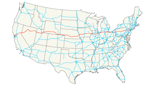
L'Interstate 80 (ou I-80) est une autoroute inter-États située aux États-Unis d'Amérique. Elle relie le centre-ville de San Francisco, en Californie, à la banlieue de New York. Elle est longue de 4671,13 kilomètres et date de 1957.
Principales villes traversées
- San Francisco, Californie
- Oakland, Californie
- Sacramento, Californie
- Reno, Nevada
- Salt Lake City, Utah
- Cheyenne, Wyoming
- Sidney, Nebraska
- North Platte, Nebraska
- Kearney, Nebraska
- Grand Island, Nebraska
- Lincoln, Nebraska
- Omaha, Nebraska
- Council Bluffs, Iowa
- Des Moines
- Iowa City
- Quad Cities, Iowa et Illinois (Davenport)
- Joliet, Illinois
- Chicago, Illinois
- Toledo, Ohio
- Cleveland Ohio
- Youngstown, Ohio
- Sharon, Pennsylvanie
- Clarion, Pennsylvanie
- Du Bois, Pennsylvanie
- Clearfield, Pennsylvanie
- Bellefonte, Pennsylvanie
- Williamsport, Pennsylvanie (par l'Interstate 180)
- Bloomsburg, Pennsylvanie
- Hazleton, Pennsylvanie
- Stroudsburg, Pennsylvanie
- Delaware Water Gap, Pennsylvanie
- New York (par l'Interstate 95)
Voir aussi
- (en) Cet article est partiellement ou en totalité issu de l’article de Wikipédia en anglais intitulé « Interstate 80 » (voir la liste des auteurs)
Autoroutes inter-États (principales en rose) 
4 5 8 10 12 15 16 17 19 20 22 24 25 26 27 29 30 35 37 39 40 43 44 45 49 55 57 59 64 65 66 68 69 70 71 72 73 74 75 76 (W) 76 (E) 77 78 79 80 81 82 83 84 (W) 84 (E) 85 86 (W) 86 (E) 87 88 (W) 88 (E) 89 90 91 93 94 95 96 97 99 (238) H-1 H-2 H-3 Autres A-1 A-2 A-3 A-4 PRI-1 PRI-2 PRI-3


Wikimedia Foundation. 2010.