- Interstate 29
-
Interstate 29 
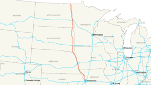
Longueur 1215,88 km (755,51 mi) Direction Nord/sud Extrémité sud 
 Interstate 35/Interstate 70 à Kansas City (Missouri)
Intersections  Interstate 80 à Council Bluffs
 Interstate 90 près de Sioux Falls
 Interstate 94 à Fargo
Extrémité nord MB 29 sur la frontière canadienne près de Pembina Réseau Interstate highway L'Interstate 29 (ou I-29) est une autoroute inter-États située aux États-Unis d'Amérique.
Distance parcourue par état
Miles km 123 198 Missouri 161 259 Iowa 252 406 Dakota du Sud 217 349 Dakota du Nord 753 1,212 Total Routes associées
- Saint Joseph (Missouri) - Interstate 229
- Sioux City - Interstate 129
- Sioux Falls - Interstate 229 (Dakota du Sud)
Voir aussi
- (en) Cet article est partiellement ou en totalité issu de l’article de Wikipédia en anglais intitulé « Interstate 29 » (voir la liste des auteurs)
Autoroutes inter-États (principales en rose) 
4 5 8 10 12 15 16 17 19 20 22 24 25 26 27 29 30 35 37 39 40 43 44 45 49 55 57 59 64 65 66 68 69 70 71 72 73 74 75 76 (W) 76 (E) 77 78 79 80 81 82 83 84 (W) 84 (E) 85 86 (W) 86 (E) 87 88 (W) 88 (E) 89 90 91 93 94 95 96 97 99 (238) H-1 H-2 H-3 Autres A-1 A-2 A-3 A-4 PRI-1 PRI-2 PRI-3 Catégorie :- Autoroute inter-États américaine


Wikimedia Foundation. 2010.