- Interstate 805
-
Interstate 805 

Longueur 45,88 km (28,51 mi) Ouverture Juillet 1964 Direction sud/nord Extrémité sud  Interstate 5 à San Diego
Intersections  California State Route 905 à San Diego
 California State Route 15 à San Diego
 Interstate 8 à San Diego
Extrémité nord  Interstate 5 à San Diego
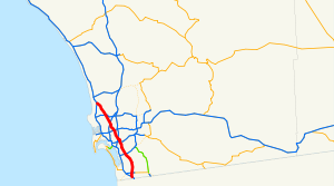
Réseau Interstate highway L'Interstate 805 (I-805), est une autoroute inter-États traversant l'agglomération de San Diego, en Californie. Elle est officiellement nommée Jacob Dekema Freeway en l'honneur de Jacob Dekema, un membre du California Department of Transportation qui s'occupa de créer le réseau autoroutier de la région. C'est une route auxiliaire de l'Interstate 5. Elle fait partie du California Freeway and Expressway System.
Description du tracé
La I-805 est un périphérique auxiliaire de l'Interstate 5. Elle commence au sud à l'I-5, à plusieurs kilomètres au nord de la frontière américano-mexicaine dans le quartier de San Diego nommé San Ysidro. Puis elle traverse les villes de Chula Vista et National City avant d'entrer dans San Diego, après quoi elle passe par les quartiers de North Park, Mission Valley, Clairemont et University City avant de rejoindre l'I-5 à Sorrento Valley.
L'autoroute, qui a de huit à dix voies, est devenue un axe de transport majeur reliant la frontière aux communautés de la South Bay, dont Chula Vista (dont Rancho del Rey et Eastlake) et National City. Elle est utilisée par les migrations pendulaires étant donné que de nombreuses entreprises s'installent à proximité, par exemple près de University City et de Sorrento Valley. En outre, puisqu'elle rejoint le Mexique, elle est utilisée par le trafic transfontalier.
Voir aussi
- (en) Cet article est partiellement ou en totalité issu de l’article de Wikipédia en anglais intitulé « Interstate 805 » (voir la liste des auteurs)
Autoroutes inter-États (principales en rose) 
4 5 8 10 12 15 16 17 19 20 22 24 25 26 27 29 30 35 37 39 40 43 44 45 49 55 57 59 64 65 66 68 69 70 71 72 73 74 75 76 (W) 76 (E) 77 78 79 80 81 82 83 84 (W) 84 (E) 85 86 (W) 86 (E) 87 88 (W) 88 (E) 89 90 91 93 94 95 96 97 99 (238) H-1 H-2 H-3 Autres A-1 A-2 A-3 A-4 PRI-1 PRI-2 PRI-3 Catégories :- Autoroute inter-États américaine
- Route de Californie
Wikimedia Foundation. 2010.
