- Interstate 476
-
Interstate 476 
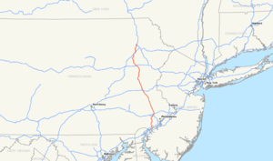
Longueur 212,59 km (132,10 mi)[1] Ouverture 1964 (complète le 19 décembre 1991[1]) Direction sud / nord Extrémité sud  I-95 près de Chester
Intersections  US 1 près de Springfield
 US 30 à Villanova
 I-76 à West Conshohocken

 I-276/PA Turnpike à Plymouth Meeting

 I-78 via US 22 près de Allentown
 US 209 près de Lehighton
 I-80 près du Hickory Run State Park
Extrémité nord  I-81 près de Clarks Summit
Réseau Interstate highway (route auxiliaire) L'Interstate 476 (I-476) est une autoroute du réseau des Interstate highways des États-Unis, située en Pennsylvanie. Elle comprend la Mid-County Expressway ou Blue Route qui parcourt les comtés de Delaware et de Montgomery, et la Northeast Extension de l'autoroute Pennsylvania Turnpike qui relie la Vallée du Delaware à la Vallée de Lehigh, aux Poconos et à l'aire urbaine de Scranton-Wilkes-Barre.
Annexes
- (en) Cet article est partiellement ou en totalité issu de l’article de Wikipédia en anglais intitulé « Interstate 476 » (voir la liste des auteurs)
Références
- Jeremy Rogoff, Mari A. Schaefer, « No remedy soon for a clogged Blue Route », The Philadelphia Inquirer, 10 juin 2007, p2
Autoroutes inter-États (principales en rose) 
4 5 8 10 12 15 16 17 19 20 22 24 25 26 27 29 30 35 37 39 40 43 44 45 49 55 57 59 64 65 66 68 69 70 71 72 73 74 75 76 (W) 76 (E) 77 78 79 80 81 82 83 84 (W) 84 (E) 85 86 (W) 86 (E) 87 88 (W) 88 (E) 89 90 91 93 94 95 96 97 99 (238) H-1 H-2 H-3 Autres A-1 A-2 A-3 A-4 PRI-1 PRI-2 PRI-3


Wikimedia Foundation. 2010.