- Interstate 24
-
Interstate 24 
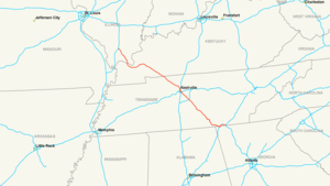
Longueur 509,1 km (316,4 mi) Ouverture Non indiqué Direction ouest / est Extrémité ouest  I-57 à Marion, IL
Intersections  I-65 à Nashville, TN
 I-40 à Nashville, TN
 I-59 près de Lookout Moutain, GA
Extrémité est  I-75 à Chattanooga, TN
Réseau Interstate highway L'Interstate 24 (ou I-24) est une autoroute inter-États située aux États-Unis d'Amérique. Elle rejoint l'Interstate 57, près de Marion, à Chattanooga, Tennessee, et l'Interstate 75.
Distances
Miles km état 38.73 62.33 Illinois 93.37 150.26 Kentucky 180.16 289.94 Tennessee 4.10 6.60 Géorgie 316.36 509.13 Total[1] Voir aussi
- (en) Cet article est partiellement ou en totalité issu de l’article de Wikipédia en anglais intitulé « Interstate 24 » (voir la liste des auteurs)
Référence
- United States Department of Transportation - Federal Highway Administration, « Route Log- Main Routes of the Eisenhower National System Of Interstate and Defense Highways - Table 1 », 31 octobre 2002. Consulté le 12 juillet 2006
Autoroutes inter-États (principales en rose) 
4 5 8 10 12 15 16 17 19 20 22 24 25 26 27 29 30 35 37 39 40 43 44 45 49 55 57 59 64 65 66 68 69 70 71 72 73 74 75 76 (W) 76 (E) 77 78 79 80 81 82 83 84 (W) 84 (E) 85 86 (W) 86 (E) 87 88 (W) 88 (E) 89 90 91 93 94 95 96 97 99 (238) H-1 H-2 H-3 Autres A-1 A-2 A-3 A-4 PRI-1 PRI-2 PRI-3 Catégorie :- Autoroute inter-États américaine


Wikimedia Foundation. 2010.