- Bakerloo line
-
Bakerloo line 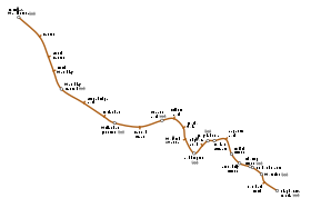
Réseau Transport for London Année d’ouverture 1906 Dernière extension 1939 Exploitant London Underground /
MetronetMatériel utilisé 1972 Tube Stock Points d’arrêt 25 Longueur 23,2 km Distance moyenne entre points d’arrêt 928 m Fréquentation
(moy. par an)95 947 000 modifier 
La Bakerloo Line est une ligne de l'Underground, le métro de Londres.
Son nom est une contraction de « Baker Street » et « Waterloo », deux stations principales qui étaient les deux terminus de la ligne lors de son ouverture en 1906.
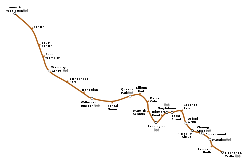
Elle va du nord-ouest vers le sud, couvre une distance de 23,2 km et dessert 25 stations, dont 15 souterraines. Les principaux centres d'intérêt desservis par cette ligne sont : Regent's Park, Oxford Circus, Piccadilly Circus et Waterloo Bridge.
En 2001, 118,4 millions de passagers ont emprunté cette ligne.
Sommaire
Histoire
À l'origine appelée la Baker Street & Waterloo Railway, la ligne a été construite par la Underground Electric Railways Company et ouvrit en 10 mars 1906, entre Baker Street et Lambeth North. Il a été étendu à Elephant & Castle cinq mois plus tard, le 5 août 1906. Lorsque les travaux ont commencés, en juin 1898, la ligne a été financée par l'entrepreneur des mines et promoteur Whitaker Wright. Il a été condamné en 1904. En conséquence, les travaux sur la ligne ont été interrompu pendant quelques mois et ils n'ont repris que, quand, Underground Electric Railways Company est intervenu et a repris le projet.
En 1913, la ligne fut prolongée à partir de son point d'origine que représentait le terminus nord à Baker Street vers l'ouest, avec des stations de correspondance avec le Great Central Railway à Marylebone et le Great Western Railway à Paddington, et une nouvelle station à Edgware Road.
Prolongement à Harrow & Wealdstone
En 1915, la ligne fut prolongée à Queen's Park, où il rejoint les lignes de la London and North Western Railway (LNWR) (maintenant la West Coast Main Line) jusqu'à Watford Junction. Les services à Watford ont été réduits dans les années 1960 et retirés en 1982; Stonebridge Park devient le nouveau terminus de la ligne.
Puis, les services à Harrow & Wealdstone ont été progressivement restauré entre 1984 et 1989.Les trains de la Bakerloo line partagent les voies avec l'Overground entre Queen's Park et Harrow & Wealdstone.
Prolongement à Stanmore
Vers le milieu des années 1930, la ligne souffrait de la congestion causée par la capacité limitée de ses voies entre Baker Street et Finchley Road. Un programme de trauvaux vers 1935-1940 comprenait la construction de nouvelles sections de tunnel entre Baker Street et Finchley Road et le remplacement des trois stations par deux nouvelles stations (St. John's Wood et Swiss Cottage). Le prolongement à Stanmore a été ouvert le 20 novembre 1939. La branche a fait partie de la ligne Bakerloo jusqu'au 1er mai 1979, lorsque des problèmes, causés par les deux branches convergentes à Baker Street a conduit à l'ouverture de la Jubilee line.
Avenir
Prolongement à Watford Junction
Au cours des prochaines années, la section nord de la ligne peut encore voir des changements suite à la décision en février 2006, de transférer la responsabilité des services de banlieue Euston-Watford du ministère des Transports (DfT) pour Transport for London (TfL). La ligne de chemin de fer (ligne Watford DC) de Queen's Park à Watford Junction, actuellement desservis par le réseau Overground, serait alors desservi que par la ligne Bakerloo.
Prolongement à Camberwell
L'extension de 1949 à Camberwell a été reproposée en 2006, par le maire de Londres, Ken Livingstone. Toutefois, il n'existe pas d'engagements fermes à cette extension et ce n'est que au statut de proposition.
Matériel roulant
Ancien matériel roulant
Matériel roulant actuel
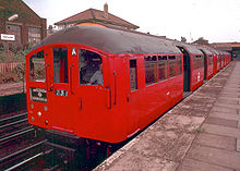
La Bakerloo line est maintenant géré entièrement par Mark 2 1972 Stock.
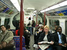
Tous les trains de la Bakerloo line sont peints aux couleurs distinctives du métro de Londres de rouge, de blanc et de bleu.
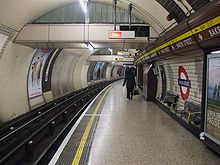
La taille utilisée sur cette ligne est la plus petite des deux tailles utilisées sur le réseau, puisque la ligne va profondément sous terre dans de petits tunnels.
Stations
Stations actuelles
Stations Image Date d'ouverture Harrow & Wealdstone (Terminus Nord) 


16 avril 1917 Kenton 
16 avril 1917 South Kenton 
3 juillet 1933 North Wembley 
16 avril 1917 Wembley Central 

16 avril 1917 Stonebridge Park 

16 avril 1917 Harlesden 
16 avril 1917 Willesden Junction 
10 mai 1915 Kensal Green 

1er octobre 1916 Queen's Park 

11 février 1915 Kilburn Park 
31 janvier 1915 Maida Vale 
6 juin 1915 Warwick Avenue 
31 janvier 1915 Paddington 


1er décembre 1913 Edgware Road 
15 juin 1907 Marylebone 

27 mars 1907 Baker Street 10 mars 1906 Regent's Park 10 mars 1906 Oxford Circus 
10 mars 1906 Piccadilly Circus 
10 mars 1906 Charing Cross 

10 mars 1906 Embankment 

10 mars 1906 Waterloo 
10 mars 1906 Lambeth North 
10 mars 1906 Elephant & Castle (Terminus Sud) 
5 août 1906 Anciennes stations
Branche Watford
Stations Image Date d'ouverture Date de fermeture Harrow & Wealdstone (Terminus Nord) 
16 avril 1917 Gare en service Headstone Lane 16 avril 1917 24 septembre 1982 Hatch End 16 avril 1917 24 septembre 1982 Carpenders Park 5 avril 1919 24 septembre 1982 Bushey 
16 avril 1917 24 septembre 1982 Watford High Street 16 avril 1917 24 septembre 1982 Watford Junction 
16 avril 1917 16 septembre 1982 Branche Stanmore
Carte
Voir aussi
Liens externes
- Bakerloo Line (Site officiel du métro)
Wikimedia Foundation. 2010.

