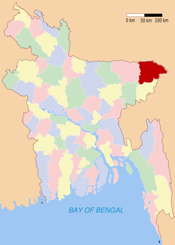
Sylhet (district)
- Sylhet (district)
-
Wikimedia Foundation.
2010.
Contenu soumis à la licence CC-BY-SA. Source : Article Sylhet (district) de Wikipédia en français (auteurs)
Regardez d'autres dictionnaires:
Sylhet District — Infobox of BD districts native name = Sylhet skyline = skyline size = skyline caption = Typical tea gardens in Sylhet District locator position = left latd = 24.92 longd = 92.00 division name = Sylhet Division population as of = 1991 population… … Wikipedia
Sylhet District — Admin ASC 2 Code Orig. name Sylhet District Country and Admin Code BD.86.60 BD … World countries Adminstrative division ASC I-II
Sylhet District — noun One of the four districts in the Sylhet Division of Bangladesh … Wiktionary
Sylhet — Administration Pays Bangladesh … Wikipédia en Français
Sylhet (zila) — Sylhet সিলেট Zila (distrito) de Bangladés … Wikipedia Español
Sylhet — This article is about the city. For the upazila or district or the administrative division, see Sylhet Sadar Upazila or Sylhet District or Sylhet Division ] [cite web|url=http://www.bbs.gov.bd/com series/syl div/syl z sum.pdf|title=Bangladesh… … Wikipedia
Sylhet Sadar Upazila — Infobox of upazilas native name = Sylhet Sadar locator position = right latd = 24.8917 longd = 91.8833 division name = Sylhet Division district = Sylhet District population as of = 1991 population total = 554412 population density = 1071 area… … Wikipedia
Sylhet (division) — 24°30′N 91°40′E / 24.5, 91.667 … Wikipédia en Français
Companiganj Upazila, Sylhet — Companiganj (Sylhet) কোম্পানীগঞ্জ Division Sylhet Division District Sylhet District … Wikipedia
Karimganj district — is an administrative district in the state of Assam in India. The district headquarters are located at Karimganj.GeographyThe district occupies an area of 1809 km². It is bounded on the northeast by Cachar District, on the east by Hailakandi… … Wikipedia


