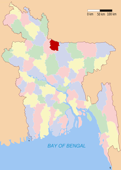
Sherpur (district)
Contenu soumis à la licence CC-BY-SA. Source : Article Sherpur (district) de Wikipédia en français (auteurs)
Regardez d'autres dictionnaires:
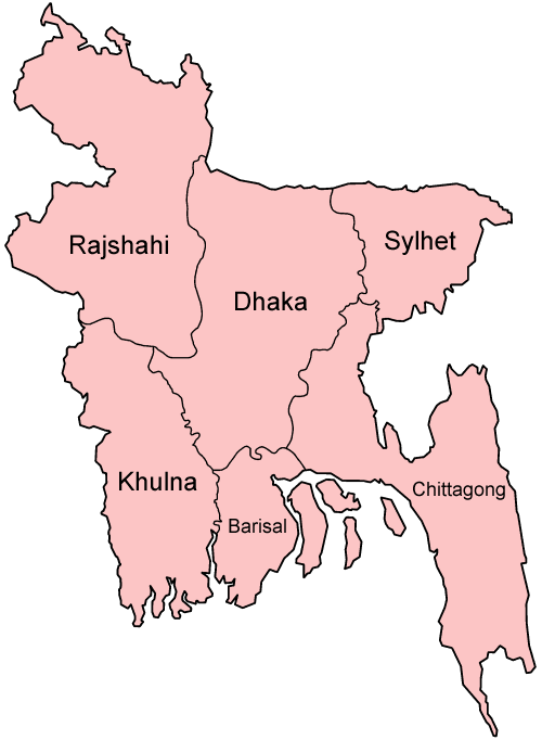
Sherpur District — Infobox of BD districts native name = Sherpur skyline = skyline size = skyline caption = locator position = right latd = 25.00 longd = 90.00 division name = Dhaka Division population as of = 1991 population total = 1,246,511 population density =… … Wikipedia
Sherpur District — Admin ASC 2 Code Orig. name Sherpur District Country and Admin Code BD.81.57 BD … World countries Adminstrative division ASC I-II
Sherpur District — noun One of the seventeen districts in the Dhaka Division of Bangladesh … Wiktionary
Sherpur — ( City of the Lion ) is a District of Bangladesh. It was the site of the historic rebellion of the Pagal Panthis against the British East India Company in the early 19th century.Sherpur District (Dhaka division) with an area of 1363.76 km², is… … Wikipedia
Sherpur (zila) — Capital Sherpur Entidad Zila … Wikipedia Español
Sherpur Sadar Upazila — Infobox of upazilas native name = Sherpur Sadar locator position = right latd = 25.0000 longd = 90.0167 division name = Dhaka Division district = Sherpur District population as of = 1991 population total = 381419 population density = 1059 area… … Wikipedia
Sherpur Kalan — is a large village and a kasvah in Pilibhit district in the Indian state of Uttar Pradesh.GeographySherpur Kalan is located at [show location on an interactive map] 28.33° N 80.25° E [1] . It has an average elevation of 160 metres.Language… … Wikipedia
Sherpur Upazila — Infobox of upazilas native name = Sherpur locator position = right latd = 24.6667 longd = 89.4167 division name = Rajshahi Division district = Bogra District population as of = 1991 population total = 229005 population density = 773 area total =… … Wikipedia
Sherpur Village — Infobox Indian Jurisdiction type = village native name = Sherpur state name = Gujarat latd = 23.47 |longd = 73.2 locator position = right district = Sabarkantha taluk names = Idar area telephone = 2778 postal code = 383410 vehicle code range = GJ … Wikipedia
Mymensingh District — Mymensingh ময়মনসিংহ District Office of the District Commissioner of Mymensingh … Wikipedia