- Heilsbronn
-
Heilsbronn 

Administration Toponyme officiel Pays  Allemagne
Land Bavière District
(Regierungsbezirk)Moyenne-Franconie Arrondissement
(Landkreis)Ansbach Code communal
(Gemeindeschlüssel)09 5 71 165 Code postal 91560 Indicatif téléphonique 09872 Immatriculation AN Nombre de quartiers
(Ortsteile)19 Site web www.heilsbronn.de Politique Bourgmestre
(Bürgermeister)Jürgen Pfeiffer Partis au pouvoir CSU Géographie Coordonnées Altitude (NN) 400 m Superficie 62,23 km2 Démographie Population 9 070 hab. (2009) Densité 146 hab./km2 modifier 
Heilsbronn est une ville allemande, située en Bavière, dans l'arrondissement d'Ansbach et le district de Moyenne-Franconie
Sommaire
Géographie
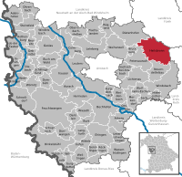 Situation de la ville de Heisbronn dans l'arrondissement d'Ansabch
Heilsbronn est située au cœur géographique de la moyenne-Franconie, entre Ansbach (17 km au sud-ouest) et Nuremberg (21 km au nord-est), à la limite avec les arrondissements de Fürth et de Roth.
Communes ayant fusionné avec Heilsbronn au cours des années 1970 :
- 1971, Weiterndorf ;
- 1972, Betzendorf, Bonnhof, Bürglein, Ketteldorf, Müncherlbach, Seitendorf ;
- 1978, Weißenbronn.
Histoire
Heilsbronn a très certainement été fondée au VIIIe siècle sous le nom de Haholdesbrunn. Son histoire est cependant très liée à celle de son abbaye cistercienne, fondée en 1132 par Rapolo d'Abenberg, qui apparaît sous le nom de Halsbrunn. Ce monastère, très riche et pourvu de domaines jusque dans la région de Ratisbonne, a été de 1297 à 1625 le lieu de sépulture de la Maison de Hohenzollern. Plus de quarante membres de cette famille, burgraves de Nuremberg, margraves d'Ansbach, princes-électeurs de Brandebourg, reposent dans son église.
En 1598, la ville est rattachée à la principauté d'Ansbach et suit donc son histoire, devenant prussienne en 1791, puis bavaroise en 1806. De 1803 à 1880, Heilsbronn a été le chef-lieu d'un arrondissement de Moyenne-Franconie avant d'être intégrée dans l'arrondissement d'Ansabch.
L'ouverture de la ligne de chemin de fer Nuremberg-Ansbach en 1875 a contribué au développement de Heilsbronn.
Démographie
Ville de Heilsbronn seule :
Évolution démographique 1910 1933 1939 1949 1961 1963 1970 1 366[1] 1 726[2] 2 050[2] 3 535 4 590 4 764 4 920 Ville de Heilsbronn dans ses limites actuelles :
Évolution démographique 1840 1871 1900 1910 1925 1933 1939 1950 1961 1970 1987 2000 2003 2009 2 814[3] 3 057[3] 3 244[3] 3 281[1] 3 720[3] 3 749[2] 4 001[2] 6 648[3] 7 027[3] 7 347[3] 7 409[3] 9 263[3] 9 407[4] 9 070[3] Monuments
- Église gothique de l'ancienne abbaye possédant un cloîte roman ;
- Anciens bâtiments conventuels.
Jumelages
Heilsbronn est jumelée avec :
- Jößnitz (Allemagne), un quartier de la ville de Plauen en Saxe.
 Objat (France), dans le département de la Corrèze, région du Limousin.
Galerie
-

La chapelle de l'ancien hôpital
-

Le réfectoire de l'ancien monastère
-

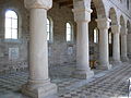
L'église de l'abbaye de Heilsbronn
-
Le cloître de l'abbaye
-
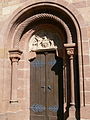
Portail roman de l'abbaye
Lien externe
Notes et références
Catégorie :- Ville de Bavière


Wikimedia Foundation. 2010.