McKeldin Beltway

McKeldin Beltway

Interstate 695 (Maryland)

I-695.svg
Interstate 695
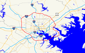
I-695 in MD map.png
Longueur 82,82 km (51,46 mi)
Ouverture 1959
Intersections I-97.svg I-97 à Glen Burnie, MD
MD Route 295.svg B-W Parkway à Linthicum, MD
I-95.svg I-95 à Arbutus, MD
US 40.svg U.S. 40 à Catonsville, MD
I-70.svg I-70 à Woodlawn, MD
I-795.svg I-795 à Pikesville, MD
I-83.svg I-83 à Lutherville-Timonium, MD
I-95.svg I-95 à White Marsh, MD
Réseau Interstate highway

L'Interstate 695 (officiellement McKeldin Beltway, surnommée Baltimore Beltway et abrégée I-695) est une autoroute inter-États de 82,82 kilomètres de long située aux États-Unis d'Amérique. Elle est la ceinture périphérique de la ville de Baltimore (Maryland).

L'autoroute est payante par endroit comme par exemple au niveau du pont Francis Scott Key Bridge qui traverse la rivière Patapsco au niveau du port de Baltimore.

Voir aussi

  • (en) Cet article est partiellement ou en totalité issu d’une traduction de l’article de Wikipédia en anglais intitulé « Interstate 695 (Maryland) ».
Autoroutes inter-États (principales en rose) Interstate Highway marker
4 5 8 10 12 15 16 17 19 20 22 24 25 26 27 29
30 35 37 39 40 43 44 45 49 55 57 59 64 65 66 68
69 70 71 72 73 74 75 76 (W) 76 (E) 77 78 79 80 81
82 83 84 (W) 84 (E) 85 86 (W) 86 (E) 87 88 (W) 88 (E)
89 90 91 93 94 95 96 97 99 (238) H-1 H-2 H-3
Autres A-1 A-2 A-3 A-4 PRI-1 PRI-2 PRI-3
  • Portail des États-Unis Portail des États-Unis
  • Portail de la route Portail de la route

Ce document provient de « Interstate 695 (Maryland) ».

Wikimedia Foundation. 2010.

Contenu soumis à la licence CC-BY-SA. Source : Article McKeldin Beltway de Wikipédia en français (auteurs)

Игры ⚽ Нужен реферат?

Regardez d'autres dictionnaires:

  • Theodore McKeldin — Infobox Politician name = Theodore R. McKeldin caption = birth date = birth date|1900|11|20|mf=y birth place = Baltimore, Maryland residence = Baltimore, Maryland death date = death date and age|1974|8|10|1900|11|20|mf=y death place = Baltimore,… …   Wikipedia

  • Baltimore Beltway — Interstate 695 (Maryland) Interstate 695 …   Wikipédia en Français
  • Interstate 695 (Maryland) — Interstate 695 Baltimore Beltway Route information …   Wikipedia

  • Anne Arundel County, Maryland — Infobox U.S. County county = Anne Arundel County state = Maryland map size = 225 founded year = 1650 seat wl = Annapolis | largest city wl = Glen Burnie leader = Janet S. Owens area total sq mi =588 area land sq mi =416 area water sq mi =172 area …   Wikipedia

  • Interstate 695 (Maryland) — Interstate 695 Longueur 82,82 km (51,46 mi) Ouverture 1959 …   Wikipédia en Français

  • Baltimore County, Maryland — Infobox U.S. County county = Baltimore County state = Maryland founded year = 1659 seat wl = Towson area total sq mi =682 area land sq mi =599 area water sq mi =83 area percentage = 12.23% census estimate yr = 2005 pop = 786113 density km2 =487… …   Wikipedia

  • University of Maryland, College Park — University of Maryland redirects here. For other uses, see University of Maryland (disambiguation). Coordinates: 38°59′15.0″N 76°56′24.0″W / 38.9875°N 76.94°W …   Wikipedia

  • Maryland — This article is about the U.S. state of Maryland. For other uses, see Maryland (disambiguation). State of Maryland …   Wikipedia

  • College Park, Maryland — College Park, MD   City   Seal …   Wikipedia

  • University of Maryland School of Public Policy — Maryland School of Public Policy Established 1981 Type Public …   Wikipedia

Share the article and excerpts

Direct link
Do a right-click on the link above
and select “Copy Link”