- Thunder Bay, Ontario
-
Thunder Bay (Ontario)
Thunder Bay 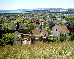
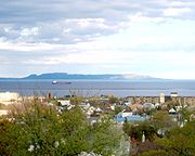
Vue du port de Thunder Bay

DétailAdministration Pays  Canada
Province  Ontario
Statut municipal Ville Constitution 1970 Maire
Mandat en coursLynn Peterson
2006 - 2010Site internet http://www.thunderbay.ca/ Démographie Population 109 140 hab. (2006) Densité 322,26 hab./km² Langue(s) officielle(s) Anglais, Français Géographie Coordonnées
géographiquesAltitudes mini. m — maxi. m Superficie 328 48 km² Fuseau horaire -5 Indicatif +1-807 Code géographique 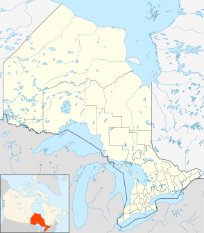

Thunder Bay est une municipalité ontarienne (Canada). C'est la deuxième grande ville du nord ontarien. Au recensement de 2006, on y a dénombré une population de 109 140[1] habitants. (Région métropolitaine de recensement : 122 907[2])
Sommaire
Situation
Thunder Bay est une ville du district de Thunder Bay dans le nord de l'Ontario.
Son port constitue un lien important dans le transport fluvial des grains et autres produits pondéreux de l'ouest à travers les Grands Lacs et la Voie maritime du Saint-Laurent à la côte Est. La ville s'appelle souvent en anglais la « Lakehead » ou la « Canadian Lakehead » due à sa situation « à la tête » de la navigation des Grands Lacs.
Attraits
Thunder Bay est le centre régional de services pour le nord-ouest ontarien. La plupart des ministères provinciaux y sont représentés.
L'université Lakehead, établie par la pression politique des professionnels et hommes d'affaires de la ville, est un gros atout, ainsi que le collège Confederation. Ces mêmes professionnels et hommes d'affaires menaient la fusion des villes de Fort William et Port Arthur en 1970[3].
Chronologie municipale
La ville a été formée en 1970 par la fusion des deux villes de Fort William et Port Arthur ainsi que les cantons de Neebing et McIntyre.
Histoire
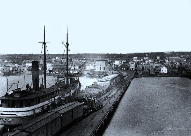
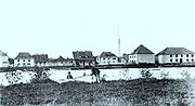 Fort William, 1865
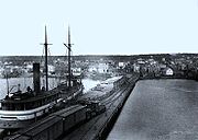 Port Arthur, 1884
Fort William, à l'origine Fort Caministigoyan établi par la France, était le noyau de la Compagnie du Nord-Ouest, qui faisait la traite des fourrures au début du XIXe siècle.
Port Arthur, à quelques kilomètres au nord, fut colonisé à partir de 1870 comme une extrémité de la route Dawson entre l'Ontario et l'ouest canadien.
Toponyme
La ville prend son nom de la vaste baie au sommet du lac Supérieur, nom qui figure comme « Baie du Tonnerre » sur les cartes françaises du XVIIIe siècle.
Gouvernement et politique
Le conseil municipal comprend un maire et douze conseillers. Le maire et cinq des conseillers sont élus par toute la population. Sept des conseillers sont élus pour les sept « wards » ou circonscriptions électorales : Current River Ward, McIntyre Ward, McKellar Ward, Neebing Ward, Northwood Ward, Red River Ward, Westfort Ward.
Géographie
 Géant endormi
Le Géant endormi (Sleeping Giant), parfois identifié au héros iroquois Hiawatha, une grande formation de mesas sur la péninsule Sibley du lac Supérieur, qui ressemble à un géant étendu sur le dos, est devenu un symbole de la ville.
La péninsule Sibley enferme les eaux de la baie (Thunder Bay), et dominine la vue du lac de la partie nord de la ville (autrefois Port Arthur, Ontario).
Le Géant endormi figure également sur le blason et le drapeau municipal.
Économie et main d'œuvre
L'exploitation de la forêt (Bowater) et la construction de matériel de transport (Bombardier) sont les plus grandes industries.
Deux établissements d'éducation supérieure: L'université Lakehead et le collège Confédération.
La principale attraction touristique est le parc historique de Fort William, construit en 1973 comme une copie d'un poste de traite de 1815.
Grands évènements sportifs accueillis
En 1981 la ville accueillit les jeux du Canada et en 1995 ceux mondiaux de ski nordiques.
Gens célèbres
- Clarence Decatur Howe, 1886-1960, homme politique
- Bora Laskin, juge en chef de la Cour Supreme du Canada
- Hugh LeCaine, 1914-1977, physicien, compositeur, inventeur
- Robert James Manion, 1881-1943, homme politique
- Robin Philpot, journaliste
- Paul Shaffer, musicien
- Jordan Staal, joueur de hockey évoluant avec les Penguins de Pittsburgh
- Eric Staal, joueur de hockey évoluant avec les Hurricanes de la Caroline
- Marc Staal, joueur de hockey évoluant avec les Rangers de New York
- Jared Staal, joueur de hockey de la OHL avec les Wolves de Sudbury
Évêché
- Diocèse de Thunder Bay
- Cathédrale Saint-Patrick de Thunder Bay
Municipalités limitrophes
Références
- ↑ Statistique Canada : Thunder Bay
- ↑ Région métropolitaine de recensement
- ↑ Thunder Bay from rivalry to unity / edited by Thorold J. Tronrud and A. Ernest Epp. Thunder Bay : Thunder Bay Historical Museum Society, 1995.
Voir aussi
Liens externes
 Portail de l’Ontario
Catégorie : Ville de l'Ontario


Wikimedia Foundation. 2010.