Pakuria
- Pakuria
-
Toau
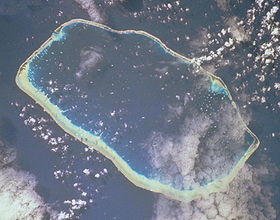
Toau, également appelé Pakuria ou Taha-a-titi[1]est un atoll du sous-groupe des Îles Palliser situé dans l'archipel des Tuamotu en Polynésie française.
Histoire
Cette section est vide, pas assez détaillée ou incomplète. Votre aide est la bienvenue !
Toau a été décrit pour la première fois par James Cook qui l'aborde en avril 1774 et le baptise Elizabeth Island[1].
Géographie
Toau est un atoll de 35 km de longueur et de 18 km de largeur maximales pour une surface d'environ 12 km2 de terres émergées. Il est constitué d’une barrière de corail qui entoure un très grand lagon d'une superficie de 561 km².
Le village principal est Maragai. Toau est rattaché administrativement à la commune de Fakarava située à 14 km au sud-est. La quarantaine d'habitants de l'atoll vivent sur la fine bande de terre qui se forme le long de la barrière de corail. Sur de nombreux atolls de Polynésie, les seules ressources sont la pêche, le copra, l’élevage de huitres perlières et pour quelques atolls, le tourisme.
Références
Catégorie : Atoll des Tuamotu
Wikimedia Foundation.
2010.
Contenu soumis à la licence CC-BY-SA. Source : Article Pakuria de Wikipédia en français (auteurs)
Regardez d'autres dictionnaires:
Pakuria block — one of the six administrative blocks of Pakur district, Jharkhand state, India, has a population (1991 census) of 79,612 … Wikipedia
Manda Upazila — Manda মান্দা Upazila … Wikipedia
Maheshpur block — one of the six administrative blocks of Pakur district, Jharkhand state, India, has a population (1991 census) of 140,665.Maheshpur Raj is block of uder pakur district in jharkhand and 33 Panchayat in maheshpur block. Maheshpur is a Town in Mahe … Wikipedia
Maheshpur Raj — Maheshpur block , one of the six administrative blocks of Pakur district, Jharkhand state, India, has a population (1991 census) of 140,665.Maheshpur is block of uder pakur district in jharkhand and 33 Panchayat in maheshpur block. Maheshpur Raj… … Wikipedia
Toau — Toau, Pakuria, or Taha a titi is a coral atoll in French Polynesia, one of the Palliser Islands (Îles Pallisier). Toau has a wide lagoon; length 35 Km, width 18 Km. The nearest land is Fakarava Atoll, located 14 Km to the Southeast. Toau Atoll is … Wikipedia
Naogaon District — Naogaon নওগাঁ District Location of Naogaon in Bangladesh … Wikipedia
Deoghar district — This article is about the district. For its eponymous headquarters, see Deoghar. Deoghar district देवघर जिला Location of Deoghar district in Jharkhand … Wikipedia
Dumka district — This article is about the district. For its eponymous headquarters, see Dumka. Dumka district दुमका जिला Location of Dumka district in Jharkhand … Wikipedia
Kolkata Suburban Railway — Infobox Public transit name = Kolkata Suburban Railway imagesize = 300px locale = Kolkata, India transit type = Rapid transit began operation = 1854 lines = Circular, Eastern and South Eastern stations = Howrah Sealdah and Kolkata track gauge =… … Wikipedia
Dumka (Lok Sabha constituency) — Dumka Lok Sabha constituency is one of the 14 Lok Sabha (parliamentary) constituencies in Jharkhand state in eastern India. This constituency is presently reserved for the candidates belonging to the Scheduled tribes. This constituency covers the … Wikipedia

 France
 France