Vahitahi

Vahitahi
Vahitahi
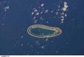
Photo satellite de la NASA
Géographie
Pays Drapeau de France France
Archipel Tuamotu
Localisation Océan Pacifique
Coordonnées 18° 47′ 00″ S 138° 50′ 00″ W / -18.783333, -138.83333318° 47′ 00″ S 138° 50′ 00″ W / -18.783333, -138.833333
Superficie 2,5 km2
Nombre d'îles 1
Géologie Atoll
Administration
Drapeau de France France
Collectivité d'outre-mer Polynésie française
District Tuamotu
Commune Nukutavake
Démographie
Population 103 hab. (2002)
Densité 41,2 hab./km2
Autres informations
Découverte 1768
Fuseau horaire UTC-10

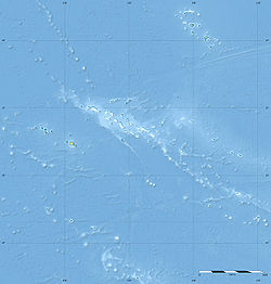
Géolocalisation sur la carte : Polynésie française

(Voir situation sur carte : Polynésie française)
Vahitahi
Vahitahi
Atolls de France

Vahitahi ou Vaitake[1] est un atoll situé dans l'archipel des Tuamotu en Polynésie française.

Géographie

Vahitahi est un petit atoll ovale de 10 km de longueur et 4,5 km de largeur maximales, avec un lagon d'une surface de 13 km2, situé à 41 km au sud-est de Akiaki le plus proche atoll. Il est administrativement associé à Nukutavake.

En 2002, Vahitahi est habité par 103 personnes situées principalement dans le village de Mohitu (précédemment nommé Temanufaara).

Histoire

Vahitahi est la première terre que le français Louis Antoine de Bougainville découvre dans le Pacifique en 1768[2]. Il nomme l'atoll Les Quatre Facardins d'après un roman de cette époque. L'année suivante, l'anglais James Cook vient à Vahitahi et le baptise Lagoon Island qui deviendra Cook's Lagoon par la suite[1].

En 1986, un petit aérodrome est construit.

Références

  1. a et b Names of the Paumotu Islands, with the Old Names So Far As They Are Known par J.L. Young dans The Journal of the Polynesian Society, Volume 8, No. 4, December 1899, p.264-8
  2. Tahiti et ses archipels par Pierre-Yves Toullelan, éditions Karthala, 1991, (ISBN 2-86537-291-X), p.61.

Wikimedia Foundation. 2010.

Contenu soumis à la licence CC-BY-SA. Source : Article Vahitahi de Wikipédia en français (auteurs)

Игры ⚽ Поможем написать курсовую

Regardez d'autres dictionnaires:

  • Vahitahi — Vahitahi, or Vaitake , is an atoll in the eastern area of the Tuamotu Archipelago, French Polynesia. Vahitahi s nearest neighbor is Akiaki, which is located 41 km to the northwest.Vahitahi is a small atoll with an elongated oval shape. It… …   Wikipedia

  • Vahitahi — Vorlage:Infobox Insel/Wartung/Höhe fehlt Vahitahi NASA Bild von Vahitahi Gewässer Pazifischer Ozean Archipel …   Deutsch Wikipedia

  • Vahitahi — (antes Les Quatre Facardins y Lagoon) es un atolón de las Tuamotu, en la Polinesia Francesa. Administrativamente es una comuna asociada a la comuna de Nukutavake. Está situado a 50 km al norte de Nukutavake. Sus coordenadas son …   Wikipedia Español

  • Vaitake — Vahitahi Vahitahi Photo satellite de la NASA Géographie Pays …   Wikipédia en Français

  • Akiaki — Vorlage:Infobox Insel/Wartung/Höhe fehlt Akiaki Karte von Akiaki Gewässer Pazifischer Ozean …   Deutsch Wikipedia

  • Akiaki — is a low coral atoll in the eastern area of the Tuamotu Archipelago, French Polynesia. Akiaki s nearest neighbor is Vahitahi, which is located 41 km to the southeast.Akiaki is a small atoll rising barely above sea level. The total land surface is …   Wikipedia

  • Liste der Tuamotu-Inseln — Der Tuamotu Archipel (Französisch Polynesien) besteht aus 73 Atollen (einschl. Gambierinseln), fünf Inseln ohne Lagune (sämtlich gehobene Atolle, sowie zwei oder drei untermeerische Riffe, bei denen es sich um untergegangene Atolle handeln könnte …   Deutsch Wikipedia

  • Tuamotus — Native name: Tuamotu Flag of the Tuamotu Islands …   Wikipedia

  • Nukutavake — …   Wikipedia

  • Amanu-Atoll — Amanu NASA Bild von Amanu Gewässer Pazifischer Ozean Archipel Anzahl der Inseln …   Deutsch Wikipedia

Share the article and excerpts

Direct link
Do a right-click on the link above
and select “Copy Link”