Memphrémagog

Memphrémagog

45° 16′ 13″ N 72° 09′ 09″ W / 45.27027778, -72.1525

Page d'aide sur l'homonymie Pour les articles homonymes, voir Memphrémagog (homonymie).
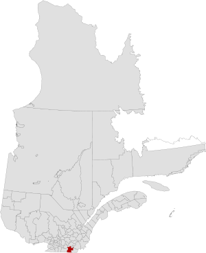
Carte de localisation de la MRC de Memphrémagog

Memphrémagog est une municipalité régionale de comté de la province du Québec (Canada) dans la région administrative de l'Estrie. Elle est composée de 17 municipalités et son chef-lieu est à Magog. Son préfet est Gérard Marinovich. La MRC de Memphrémagog est située dans la circonscription électorale d'Orford qui est représenté à l'Assemblée nationale du Québec par monsieur Pierre Reid.

Sommaire

Histoire

La MRC de Memphrémagog a été constituée le 1er janvier 1982.

Municipalités de la MRC de Memphrémagog

Municipalité Statut Superficie Population
2005
Densité
Austin Municipalité 72,62 km² 1 300 hab. 17,9 hab./km²
Ayer's Cliff Municipalité de village 11,15 km² 1 165 hab. 104,5 hab./km²
Bolton-Est Municipalité 80,78 km² 713 hab. 8,8 hab./km²
Eastman Municipalité 68,87 km² 1 453 hab. 21,1 hab./km²
Hatley Municipalité 60,67 km² 715 hab. 11,8 hab./km²
Hatley Municipalité de canton 71,18 km² 1 595 hab. 22,4 hab./km²
Magog Ville 145,68 km² 23 105 hab. 158,6 hab./km²
North Hatley Municipalité de village 3,23 km² 780 hab. 241,5 hab./km²
Ogden Municipalité 75,49 km² 767 hab. 10,2 hab./km²
Orford Municipalité de canton 139,81 km² 2 956 hab. 21,1 hab./km²
Potton Municipalité de canton 264,10 km² 1 834 hab. 6,9 hab./km²
Saint-Benoît-du-Lac Municipalité 2,27 km² 45 hab. 19,8 hab./km²
Sainte-Catherine-de-Hatley Municipalité 81,43 km² 2 064 hab. 25,3 hab./km²
Saint-Étienne-de-Bolton Municipalité 47,99 km² 513 hab. 10,7 hab./km²
Stanstead Ville 21,93 km² 3 098 hab. 141,3 hab./km²
Stanstead Municipalité de canton 113,93 km² 1 086 hab. 9,5 hab./km²
Stukely-Sud Municipalité de village 66,31 km² 1 048 hab. 15,8 hab./km²
Total 1 327,44 km² 44 237 hab. 33,3 hab./km²

MRC et territoires équivalents

Liens externes


Wikimedia Foundation. 2010.

Contenu soumis à la licence CC-BY-SA. Source : Article Memphrémagog de Wikipédia en français (auteurs)

Игры ⚽ Поможем решить контрольную работу

Regardez d'autres dictionnaires:

  • Memphremagog — Memphrémagog Pour les articles homonymes, voir Memphrémagog (homonymie). Carte de localisation de la MRC de Memphrémagog …   Wikipédia en Français

  • Memphremagog — (Memorobka), See, dessen Nordende in Untercanada, dessen Südende in Vermont liegt; 7 Meilen lang, bis zu 1 Meile breit; er ergießt sein Wasser durch den Magog Outlet in den St. Francis River in Canada …   Pierer's Universal-Lexikon

  • Memphremagog — [mem΄fri mā′gäg] [AmInd, lit., beautiful water] lake in N Vt. & S Quebec, Canada: c. 27 mi (43 km) long; 2 4 mi (3.2 6.4 km) wide …   English World dictionary

  • Memphrémagog — Municipalité régionale de comté Memphrémagog Staat Kanada Provinz Québec Verwaltungsregion Estrie …   Deutsch Wikipedia

  • Memphrémagog Regional County Municipality, Quebec — Memphremagog redirects here. For the lake, see Lake Memphremagog. Memphrémagog   Regional County Municipality   Quebec …   Wikipedia

  • Memphrémagog (homonymie) — Cette page d’homonymie répertorie les différents sujets et articles partageant un même nom.  Canada Memphrémagog est une municipalité régionale de comté de la province de Québec dans la région administrative de …   Wikipédia en Français

  • Memphremagog, Lake — Lake that crosses the U.S. Canadian border. Extending from northern Vermont, U.S., into southern Quebec, Can., it is 27 mi (43 km) long and only 1–2 mi (1.5–3 km) wide for most of its length. It has several large bays, including Fitch Bay and… …   Universalium

  • Memphremagog — /mem free may gog/, n. Lake, a lake on the boundary between the U.S. and Canada, between N Vermont and S Quebec. 30 mi. (48 km) long. * * * …   Universalium

  • Memphremagog — /mɛmfrəˈmeɪgɒg/ (say memfruh maygog) noun a lake on the border between the US and Canada in northern Vermont and southern Quebec. About 43 km long and up to 6 km wide …  

  • Memphremagog — /mem free may gog/, n. Lake, a lake on the boundary between the U.S. and Canada, between N Vermont and S Quebec. 30 mi. (48 km) long …   Useful english dictionary

Share the article and excerpts

Direct link
Do a right-click on the link above
and select “Copy Link”