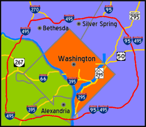
- Interstate 495 (capital beltway)
-
Interstate 495 (Capital Beltway)

Interstate 495 
Longueur 102 (64 mi) Direction Autoroute périphérique Intersections  I-295 près de Forest Heights
 US 50 (I-595) près de Glenarden
 I-95 near College Park
 I-270 près de Bethesda
 SR 267 près de Tysons Corner
 I-66 près de Falls Church

 I-95/I-395 près de Springfield
Réseau Interstate highway L'Interstate 495 (I-495) est une autoroute inter-états américaine qui entoure le Washington (District de Columbia) et ses banlieues du Maryland et de Virginie. Elle est aussi connue sous le nom de Capital Beltway ou the Beltway. Son nom initial, lorsqu'elle était au stade de projet, était Circumferential Highway. L'accord de construction a été donné par le gouvernement fédéral le 28 septembre 1955 et l'autoroute a ouvert progressivement, ouverte le 21 décembre 1961 et complétée le 17 août 1964.
Voir aussi
- (en) Cet article est partiellement ou en totalité issu d’une traduction de l’article de Wikipédia en anglais intitulé « Interstate 495 (Capital Beltway) ».
Autoroutes inter-États (principales en rose) 
4 5 8 10 12 15 16 17 19 20 22 24 25 26 27 29 30 35 37 39 40 43 44 45 49 55 57 59 64 65 66 68 69 70 71 72 73 74 75 76 (W) 76 (E) 77 78 79 80 81 82 83 84 (W) 84 (E) 85 86 (W) 86 (E) 87 88 (W) 88 (E) 89 90 91 93 94 95 96 97 99 (238) H-1 H-2 H-3 Autres A-1 A-2 A-3 A-4 PRI-1 PRI-2 PRI-3 Liens externes
- Official Study Website published by the Maryland State Highway Adminsitration
- sur Roads to the future
Catégories : Autoroute inter-États américaine | Washington, DC
Wikimedia Foundation. 2010.
