Bristol Channel

Bristol Channel

Canal de Bristol

Canal de Bristol
Bristol channel detailed map.png
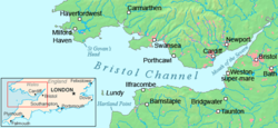
Type Bras de mer
Localisation Océan Atlantique
Pays côtier(s) Royaume-Uni Royaume-Uni

Le canal de Bristol (Bristol Channel en anglais, Môr Hafren en gallois) est un bras de mer du Royaume-Uni séparant les Galles du Sud de l'Angleterre du Sud-Ouest. Il s'étend de l'estuaire du Severn à la mer Celtique de l'océan Atlantique nord. Son nom vient de la ville de Bristol en Angleterre

Géographie

Le canal a une longueur d'environ 135 km et une largeur maximale de 50 m. Au nord se trouve le pays de Galles et les villes de Cardiff, Swansea, Newport et Chepstow. Sur la côte anglaise se trouvent les villes de Bristol, Portishead, Weston-super-Mare et Barnstaple.

Il y a de nombreuses petites îles peu habitées dans le canal :

Sur ces îles se trouvent des réserves naturelles et de nombreux oiseaux, des colonies de goélands, mouettes, fulmars, cormorans, petit pingouin, guillemot de Troïl, macareux moine, huîtrier pie, alouette des champs, pipit farlouse, merle noir, rouge-gorge, linotte mélodieuse, tadorne.

Dans le canal se produisent de très grandes marées, la 2e plus grande du monde derrière la Baie de Fundy au Canada - à marée basse, on trouve de vastes bancs de boue aux bords du canal.

Transport

Il y a un tunnel pour les trains - le Severn Tunnel, et 2 ponts routiers, les Ponts de Severn, tous au-dessus de l'estuaire.

Référence

  • (en) Cet article est partiellement ou en totalité issu d’une traduction de l’article de Wikipédia en anglais intitulé « Bristol Channel ».
  • Portail du monde maritime Portail du monde maritime
Ce document provient de « Canal de Bristol ».

Wikimedia Foundation. 2010.

Contenu soumis à la licence CC-BY-SA. Source : Article Bristol Channel de Wikipédia en français (auteurs)

Игры ⚽ Поможем сделать НИР

Regardez d'autres dictionnaires:

  • Bristol Channel — Bristol Chan|nel the Bristol Channel an area of water between South Wales and southwest England which goes from the Atlantic Ocean to the mouth of the Severn River …   Dictionary of contemporary English

  • Bristol Channel — arm of the Atlantic, between S Wales & SW England: c. 85 mi (137 km) long …   English World dictionary

  • Bristol Channel — Map of the Bristol Channel Sunrise looking no …   Wikipedia

  • Bristol Channel — Karte des Bristolkanals Satellitenbild Der Bristolkanal (englisch Bristol Channel; walisisch Môr Hafren) ist eine Bucht an der We …   Deutsch Wikipedia

  • Bristol Channel — Sp Bristolio įlanka Ap Bristol Channel L Airijos j., D. Britanija (Anglija) …   Pasaulio vietovardžiai. Internetinė duomenų bazė

  • Bristol Channel floods, 1607 — On 30 January, 1607 (New style) the Bristol Channel floods resulted in the drowning of an estimated 2,000 or more people, with houses and villages swept away, an estimated convert|200|sqmi|km2|0 of farmland inundated and livestock destroyed,cite… …   Wikipedia

  • Bristol Channel — an inlet of the Atlantic, between S Wales and SW England, extending to the mouth of the Severn estuary. 85 mi. (137 km) long. * * * Inlet of the Atlantic Ocean, southwestern England. It extends about 85 mi (135 km) between southern Wales and… …   Universalium

  • Bristol Channel — geographical name channel between S Wales & SW England …   New Collegiate Dictionary

  • Bristol Channel — noun an inlet of the Atlantic Ocean between South Wales and England; an extension of the estuary of the River Severn …   Wiktionary

  • BRISTOL CHANNEL —    an inlet in SW. of England, between S. Wales and Devon and Cornwall, 8 m. in length, from 5 to 43 in breadth, and with a depth of from 5 to 40 fathoms; is subject to very high tides, and as such dangerous to shipping; numerous rivers flow into …   The Nuttall Encyclopaedia

Share the article and excerpts

Direct link
Do a right-click on the link above
and select “Copy Link”