Sidlaw Hills

Sidlaw Hills

56°30′N 3°10′W / 56.5, -3.167

Sidlaw Hills
Scotland relief location map.jpg
Sidlaw Hills
Sidlaw Hills

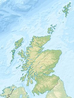
Localisation des Sidlaw Hills en Écosse.
Géographie
Altitude 455 m, Craigowl Hill
Longueur 45 km
Administration
Pays Drapeau : Royaume-Uni Royaume-Uni
Nation constitutive Drapeau d'Écosse Écosse
Géologie
Roches Roches volcaniques

Les Sidlaw Hills sont une chaîne de collines d'origine volcanique s'étendant dans les comtés de Perth et d'Angus en Écosse. Elles sont aussi appelées simplement The Sidlaw, law étant le mot scot, issu du vieil anglais, pour colline. L'élément sid est sans doute dérivé du gaélique écossais sidh, qui désigne l’Autre Monde dans la mythologie celtique ; en effet, de nombreux tumulus préhistoriques sont toujours visibles sur plusieurs sites, et la croyance populaire les tenait autrefois pour les résidences des Tuatha Dé Danann.

Sommaire

Description

Craigowl Hill

Les Sidlaw s'étendent sur environ 45 kilomètres entre Kinnoull Hill, près de Perth, jusqu'au nord-est de Forfar[1].

Le point culminant de la chaîne est Craigowl Hill ; c'est sur le sommet voisin de Gallow Hill qu'est construit l'émetteur transmettant la télévision et la radio à la région.

Les autres sommets d'importance sont Ark Hill et King's Seat.

Sites d'intérêt

Dunsinane Hill est mentionnée dans la pièce Macbeth de William Shakespeare, et sur Auchterhouse Hill s'élevait autrefois un fort militaire.

A proximité des Sidlaw se trouvent le château de Glamis et la pierre d'Eassie, une pierre picte gravée, en forme de croix, située dans une église en ruines du village d'Eassie[2]

Les Sidlaw en musique

Sidlaw Hills est le nom d'un Scottish composé pour le fiddle (violon) par Jim Watson[3], un musicien de Blairgowrie (1868 - 1931)

Références

  1. United Kingdom Ordnance Survey Map, Landranger (2005)
  2. (en) C.Michael Hogan, Eassie Stone, The Megalithic Portal, ed. Andy Burnham, Oct. 7, 2007
  3. [http://www.springthyme.co.uk/album05/05songtexts.html Tom Hughes and His Border Fiddle

Wikimedia Foundation. 2010.

Contenu soumis à la licence CC-BY-SA. Source : Article Sidlaw Hills de Wikipédia en français (auteurs)

Игры ⚽ Нужно решить контрольную?

Regardez d'autres dictionnaires:

  • Sidlaw Hills — (spr. ßiddlao), Hügelzug in Schottland, im N. des Firth of Tay, erstreckt sich von Perth in nordwestlicher Richtung gegen Montrose und erreicht im King s Seat 352 m Höhe …   Meyers Großes Konversations-Lexikon

  • SIDLAW HILLS —    a range of hills extending from Kinnoul Hill, near Perth, NE. to Brechin, in Forfarshire; most interesting point Dunsinane (1114 ft.) …   The Nuttall Encyclopaedia

  • Sidlaw — Hills Sidlaw Hills Géographie Altitude 455 m, Craigowl Hill Ma …   Wikipédia en Français

  • Sidlaws — Sidlaw Hills Sidlaw Hills Géographie Altitude 455 m, Craigowl Hill Ma …   Wikipédia en Français

  • Сидло-Хилс — (Sidlaw Hills)Sidlaw Hills, возвышенность, гряда холмов на В. центр. Шотландии, отделяющая долину Карс оф Гофри от долины Стратмор и протянувшаяся от г.Перт до г.Форфар. Самая высокая точка – гора Крейгоул Хилл (455 м) …   Страны мира. Словарь

  • Forfarshire —    FORFARSHIRE, a maritime county, in the east of Scotland, bounded on the north by the counties of Aberdeen and Kincardine; on the east, by the German Ocean; on the south, by the Frith of Tay; and on the west, by Perthshire. It lies between 56°… …   A Topographical dictionary of Scotland

  • Perthshire —    PERTHSHIRE, an inland and most extensive county, nearly in the centre of Scotland, bounded on the north and north west by Inverness shire; on the east by the county of Forfar; on the south east by the counties of Fife and Kinross; on the south …   A Topographical dictionary of Scotland

  • Auchterhouse —    AUCHTERHOUSE, a parish, in the county of Forfar, 7 miles (N. W. by N.) from Dundee; containing, with the villages of Dronley and Kirkton, 769 inhabitants. This parish, the name of which is of uncertain derivation, is nearly of triangular form …   A Topographical dictionary of Scotland

  • Sidlaws — The Sidlaws (Scottish Gaelic: Na Sidhbheanntan [http://www.iol.ie/ carsfrn/Tasgaidh%202.htm] ) are a range of hills of volcanic origin in the counties of Perthshire and Angus in Scotland that extend for 30 miles (45 km) from Kinnoull Hill, near… …   Wikipedia

  • Newtyle —    NEWTYLE, a parish, in the county of Forfar; containing 1264 inhabitants, of whom a large part are in the New Village, 2¼ miles (S. by E.) from Meigle. This place is conjectured to have taken its name from the slate, or material for tiles,… …   A Topographical dictionary of Scotland

Share the article and excerpts

Direct link
Do a right-click on the link above
and select “Copy Link”