- North West Border Frontier
-
Province de la Frontière-du-Nord-Ouest
شمال مغربی سرحدی صوبہ

Province de la Frontière-du-Nord-Ouest
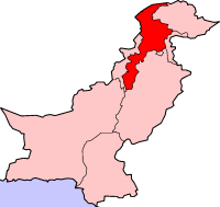
Localisation de la Province de la Frontière-du-Nord-Ouest (en rouge) à l'intérieur du PakistanAdministration Pays  Pakistan
Type Province Capitale Peshawar Géographie Superficie 74 521 km² Démographie Population 20 215 000 hab. (est. 2008) Densité 271,3 hab./km² La Province de la Frontière du Nord-Ouest est la plus petite des quatre provinces du Pakistan. Son chef-lieu est Peshawar. La langue principale est le pashto.
Sommaire
Histoire
La région était à l'origine une partie du royaume antique de Gandhâra (avec le Cachemire et l'Afghanistan oriental). Par la suite, il fit partie du royaume de Shahi. Dans des temps modernes, il a été intégré à l'Empire moghol. En 1747, quand la domination moghole s'est effondrée, les tribus ont tenu une Loya Jirga, c’est-à-dire une réunion et ont décidé de rejoindre l'Empire Durrani, tout en conservant une autonomie pachtoune.
Durant le règne britannique en Inde, ces territoires sont devenus une partie de la Province de la Frontière du Nord-Ouest (NWFP) de l'Inde britannique.
Après l'indépendance en 1947, un référendum a été tenu : la province a voté pour devenir région du Pakistan.
Certains Pachtounes appellent cette province Pakhtunkhwa qui veut dire « Terre des Pachtouns » en pashto, d'autres Pakistanais l'appellent parfois Sarhad en ourdou.
En 2005, la population de cette région est d'environ 21 millions d'habitants sans compter les 3 millions de réfugiés afghans. Depuis la guerre d'Afghanistan en 2001, la province, à travers laquelle passent l'une des routes principales de réapprovisionnement de l'Force internationale d'assistance et de sécurité (ISAF), est en effet lourdement affectée par la guerre, étant elle-même le lieu d'attentats-suicides perpétrés contre les forces militaires pakistanaises et abritant plusieurs mouvements islamiques violents tel le Tehrik-e-Nifaz-e-Shariat-e-Mohammadi.
Divisions historiques de la province
(jusqu'en 2000)District Superficie (km²) Population
(Millions)Bannu 4.391 1,60 Dera Ismail Khan 9.005 1,60 Hazara 17.194 4,70 Kohat 7.012 2,30 Malakand 29.872 5,00 Mardan 3.046 3,50 Peshawar 4.001 5,30 Liste des districts
no District Capitale Superficie (km²) Population (1998) Densité (habitants/km²) 1. Abbottabad Abbottabad 1 967 880 666 448 2. Bannu Bannu 1 227 675 667 551 3. Batagram Batagram 1 301 307 278 236 4. Buner Daggar 1 865 506 048 271 5. Charsadda Charsadda 996 1 022 364 1 026 6. Chitral Chitrâl 14 850 318 689 21 7. Dera Ismail Khan Dera Ismail Khan 7 326 852 995 116 8. Hangu Hangu 1 097 314 529 287 9. Haripur Haripur 1 725 692 228 401 10. Karak Karak 3 372 430 796 128 11. Kohat Kohat 2 545 562 644 221 12. Kohistan Dassu 7 492 472 570 63 13. Lakki Marwat Lakki Marwat 3 164 490 025 155 14. Lower Dir Timergara 1 582 717 649 454 15. Malakand Batkhela 952 452 291 475 16. Mansehra Mansehra 4 579 1 152 839 252 17. Mardan Mardan 1 632 1 460 100 895 18. Nowshera Nowshera 1 748 874 373 500 19. Peshawar Peshawar 1 257 2 019 118 1 606 20. Shangla Alpurai 1 586 434 563 274 21. Swabi Swabi 1 543 1 026 804 665 22. Swat Saidu Sharif 5 337 1 257 602 236 23. Tank Tank 1 679 238 216 142 24. Upper Dir Dir 3 699 575 858 156 Province de la Frontière-du-Nord-Ouest Peshawar 74 521 17 735 912 238 Villes les plus importantes
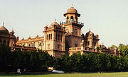
 Une université à Peshawar, capitale de la province.
Ville Population (est. 2009)[1] Districts Peshawar 1 390 874 District de Peshawar Mardan 340 898 District de Mardan Mingora 268 297 District de Swat Kohat 170 800 District de Kohat Abbottabad 144 109 District d'Abbottabad Swabi 111 175 District de Swabi Dera Ismail Khan 109 686 District de Dera Ismail Khan Charsadda 103 260 District de Charsadda Références
- ↑ (en) Statistique sur les plus grandes villes du Pakistan, World Gazetteer. Consulté le 9 juin 2009
- Portail du monde indien
Catégories : Province de la Frontière-du-Nord-Ouest | Province du Pakistan
Wikimedia Foundation. 2010.


