Nieuw-Lekkerland

Nieuw-Lekkerland
Nieuw-Lekkerland
Blason de Nieuw-Lekkerland
Héraldique
Drapeau de Nieuw-Lekkerland
Drapeau

Administration
Pays Drapeau : Pays-Bas Pays-Bas
Province Hollande-Méridionale
Code postal 2957, 2961
Géographie
Coordonnées 51° 52′ 59″ N 4° 40′ 01″ E / 51.883, 4.66751° 52′ 59″ Nord
       4° 40′ 01″ Est
/ 51.883, 4.667
  
Superficie 1 277 ha = 12,77 km2
  - Terre 1 040 ha = 10,40 km2
  - Eau 238 ha = 2,38 km2
Démographie
Population 9 466 hab.
Densité 906 hab./km2
Localisation
Localisation de Nieuw-Lekkerland

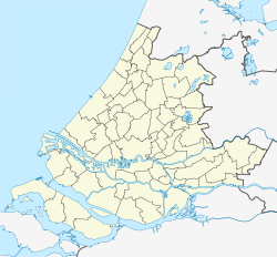
Géolocalisation sur la carte : Hollande-Méridionale

(Voir situation sur carte : Hollande-Méridionale)
Nieuw-Lekkerland

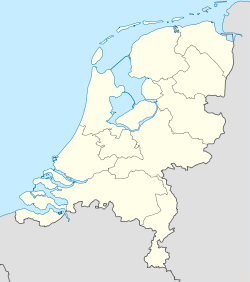
Géolocalisation sur la carte : Pays-Bas

(Voir situation sur carte : Pays-Bas)
Nieuw-Lekkerland

Nieuw-Lekkerland est une commune néerlandaise de la province de Hollande-Méridionale, le long de la Lek.

Le village de Nieuw-Lekkerland est constitué à l'origine de deux hameaux, Dorp et Middelweg, distants de 2 km, séparés par des pâtures. Entre les deux, il y a tellement de constructions que les deux se touchent pratiquement.

À l'origine, Nieuw-Lekkerland est une commune agricole, où se sont installées des industries le long de la rivière Lek. Il y a aussi une zone industrielle à l'intérieur des digues, à la limite du village.

Localités

La commune est constituée du bourg de Nieuw-Lekkerland et du village de Kinderdijk, partagé avec la commune d'Alblasserdam.

Notes et références

Lien externe

(nl) Site officiel


Wikimedia Foundation. 2010.

Contenu soumis à la licence CC-BY-SA. Source : Article Nieuw-Lekkerland de Wikipédia en français (auteurs)

Игры ⚽ Нужно сделать НИР?

Regardez d'autres dictionnaires:

  • Nieuw-lekkerland — Nieuw Lekkerland …   Wikipédia en Français

  • Nieuw-Lekkerland —   Municipality   Flag …   Wikipedia

  • Nieuw-Lekkerland — Nieuw Lẹkkerland   [ niːu̯ ], Gemeinde in der Provinz Südholland, Niederlande, am linken Ufer des Lek, 9 100 Einwohner; Metallindustrie, Betonfertigteilherstellung. Zu Nieuw Lekkerland gehört Kinderdijk …   Universal-Lexikon

  • Nieuw-Lekkerland — Gemeinde Nieuw Lekkerland Flagge Wappen Provinz …   Deutsch Wikipedia

  • Nieuw-Lekkerland — Original name in latin Nieuw Lekkerland Name in other language N iv Lekkerland, Ньив Леккерланд State code NL Continent/City Europe/Amsterdam longitude 51.88915 latitude 4.68653 altitude 0 Population 9535 Date 2013 06 09 …   Cities with a population over 1000 database

  • Kinderdijk — Réseau des moulins de Kinderdijk Elshout * Patri …   Wikipédia en Français

  • Réseau des moulins de Kinderdijk-Elshout — Kinderdijk Moulins à Kinderdijk Kinderdijk est un village des Pays Bas, situé à cheval sur le territoire des communes de Nieuw Lekkerland et d Alblasserdam, à environ 15 km à l est de Rotterdam. Le village se trouve dans un polder au… …   Wikipédia en Français

  • Ньив-Леккерланд — Город Ньив Леккерланд нидерл. Nieuw Lekkerland Флаг Герб …   Википедия

  • Kinderdijk — Coordinates: 51°53′N 4°38′E / 51.883°N 4.633°E / 51.883; 4.633 …   Wikipedia

  • List of places in the Netherlands — This is an alphabetical list of places (cities, towns, villages) in the Netherlands. Lists per province can be found at:* List of towns in Groningen * List of towns in Friesland * List of towns in Drente * List of towns in Overijssel * List of… …   Wikipedia

Share the article and excerpts

Direct link
Do a right-click on the link above
and select “Copy Link”