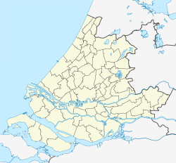
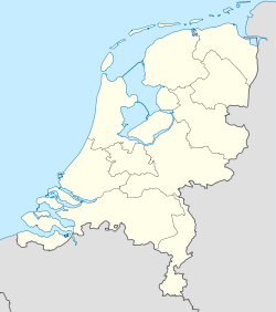
Zoeterwoude
Contenu soumis à la licence CC-BY-SA. Source : Article Zoeterwoude de Wikipédia en français (auteurs)
Regardez d'autres dictionnaires:
Zoeterwoude — Gemeinde Zoeterwoude Flagge Wappen Provinz Südholland … Deutsch Wikipedia
Zoeterwoude — Infobox Settlement official name = Zoeterwoude imagesize = 225px image caption = flag size = 120x100px image shield = Zoeterwoude coa.gif shield size = 120x100px mapsize = 280px subdivision type = Country subdivision name = Netherlands… … Wikipedia
Zoeterwoude — Sp Zùtervaudė Ap Zoeterwoude L Nyderlandai … Pasaulio vietovardžiai. Internetinė duomenų bazė
Zoeterwoude-Dorp — 52°7′9″N 4°29′48″E / 52.11917, 4.49667 … Wikipédia en Français
Zoeterwoude-Rijndijk — 52°8′32″N 4°31′32″E / 52.14222, 4.52556 … Wikipédia en Français
Zoeterwoude-Dorp — Dutch town locator maps mun town caption = The town centre (red) and the statistical district (light green) of Zoeterwoude Dorp in the municipality of Zoeterwoude.Zoeterwoude Dorp is a town in the Dutch province of South Holland. It is a part of… … Wikipedia
Zoeterwoude-Rijndijk — Dutch town locator maps mun town caption = Zoeterwoude Rijndijk in the municipality of Zoeterwoude.Zoeterwoude Rijndijk is a village in the Dutch province of South Holland. It is a part of the municipality of Zoeterwoude, and lies about 5 km… … Wikipedia
Westeinde (Zoeterwoude) — 52°6′53″N 4°29′9″E / 52.11472, 4.48583 … Wikipédia en Français
Westeinde (Zoeterwoude) — Dutch town locator maps mun town caption = Westeinde in the municipality of Zoeterwoude.Westeinde is a village in the Dutch province of South Holland. It is a part of the municipality of Zoeterwoude, and lies about 6 km north of Zoetermeer.The… … Wikipedia
Gemeente Zoeterwoude — Admin ASC 2 Code Orig. name Gemeente Zoeterwoude Country and Admin Code NL.11.0638 NL … World countries Adminstrative division ASC I-II

 Pays-Bas