Gulf Intracoastal Waterway
- Gulf Intracoastal Waterway
-

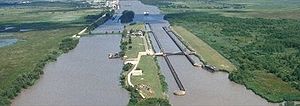
Vue aérienne de l'
Intercastal Waterway.
Le Gulf Intracoastal Waterway est une portion de l'Intracoastal Waterway située le long du Golfe du Mexique, au sud des États-Unis. Il s'agit d'un ensemble de canaux qui relient les fleuves qui se jettent dans le golfe du Mexique. Le Gulf Intracoastal Waterway est aussi une voie d'eau qui parcourt environ 1700 km de la ville de Carrabelle (Floride), à celle de Brownsville (Texas). Capable d'accueillir des navires de 3,7 mètres de tirant d'eau, elle fut d'abord aménagée pour la navigation des barges.
Ports
Liste des ports principaux situés sur ou à proximité du Gulf Intracoastal Waterway :
Voir aussi
Notes
Liens internes
Wikimedia Foundation.
2010.
Contenu soumis à la licence CC-BY-SA. Source : Article Gulf Intracoastal Waterway de Wikipédia en français (auteurs)
Regardez d'autres dictionnaires:
Gulf Intracoastal Waterway — The Gulf Intracoastal Waterway is the portion of the Intracoastal Waterway located along the Gulf Coast of the United States. It is a navigable inland waterway running approximately 1700 kilometers (1050 mi) from Carrabelle, Florida, to… … Wikipedia
Gulf Intracoastal Waterway — Der Gulf Intracoastal Waterway bei Port Bolivar, Texas … Deutsch Wikipedia
Gulf Intracoastal Waterway — System of inland waterways, including rivers and canals, along the U.S. coast of the Gulf of Mexico. It extends from Apalachee Bay, Fla., west to the Mexican border at Brownsville, Texas, a distance of more than 1,100 mi (1,770 km). It includes… … Universalium
Gulf Intracoastal Waterway. — See under Intracoastal Waterway. * * * … Universalium
Gulf Intracoastal Waterway. — See under Intracoastal Waterway … Useful english dictionary
Waterways forming and crossings of the Gulf Intracoastal Waterway — This is a list of waterways that form the Gulf Intracoastal Waterway and crossings (bridges, tunnels and ferries) across it. The list runs from west to east (Brownsville, Texas to Carrabelle, Florida), in order of decreasing mile markers to… … Wikipedia
Gulf Intracoastal Waterway — … Useful english dictionary
Intracoastal Waterway — [ɪntrə kəʊstl wɔːtəweɪ], Schifffahrtsweg im Osten und Süden der USA, zieht sich (4 800 km) an der Küste des Atlantiks und des Golfs von Mexiko entlang; benutzt Buchten, Lagunen, Flüsse und Kanäle und ist vielfach mit anderen Binnenwasserstraßen … Universal-Lexikon
Intracoastal Waterway — The Intracoastal Waterway is a 4,800 km (3,000 mile) waterway along the Atlantic and Gulf coasts of the United States. Some lengths consist of natural inlets, salt water rivers, bays, and sounds; others are man made canals.The waterway runs the… … Wikipedia
Intracoastal Waterway — Le Gulf Intracoastal Waterway à son intersection avec Bayou Perot, sur le chemin de la Nouvelle Orléans … Wikipédia en Français

