- Vetil
-
Veteli
Veteli Pays Finlande
Province historique Ostrobotnie Province Finlande occidentale Région Ostrobotnie du Sud Fondée en 1865 Droits de Cité non Langue officielle unilingue finnois Altitudes minimale : env 50 m
maximale : 150 mSuperficie
dont eau520.57 km²
15.07 km²Rang
(Superficie hors eau)164 e Population
Rang population3 543[1] hab.
(31.12.2006)
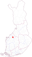
265 eDensité 7.0 hab./km² Veteli (Vetil en suédois) est une municipalité de l'Ouest de la Finlande, dans la province de Finlande occidentale et la région d'Ostrobotnie-Centrale.
La commune est traversée par la rivière Perhonjoki. Les abords immédiats de la rivière et des principaux villages sont cultivés, le reste de la commune étant couvert de forêts et de marais. Les industries sont pratiquement absentes, la commune est assez pauvre et dépend largement de l'agriculture (28% des emplois totaux).
Veteli est connue pour son circuit automobile (circuit de Kemora) construit en 1983. La piste mesure 2 733 mètres de long.
La capitale régionale Kokkola est à 54 km, et Helsinki à 480 km. Les municipalités voisines sont Kaustinen au nord, Halsua à l'est, Perho au sud-est, Vimpeli et Lappajärvi au sud (les deux en Ostrobotnie du Sud), et enfin Kronoby à l'ouest (Ostrobotnie).
Références
Liens externes
- (fi)(en)(de)(sv) Municipalité de Veteli

Municipalités d'Ostrobotnie-Centrale 
Halsua - Himanka - Kannus - Kaustinen - Kokkola - Kälviä - Lestijärvi - Lohtaja - Perho - Toholampi - Ullava - Veteli
Finlande occidentale | Finlande Portail de la Finlande
Catégorie : Municipalité d'Ostrobotnie-Centrale


Wikimedia Foundation. 2010.