Terbant

Terbant

Terband

52°59′44″N 5°54′11″E / 52.99556, 5.90306

Terband
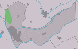
Map NL It Hearrenfean Terbant.png
Vue de la localité sur la carte des Pays-Bas

Pays Pays-Bas Pays-Bas
Commune Heerenveen
Province Frise
Nombre d'habitants 298 (2006)
Code postal 8449

Terband est un village situé dans la commune néerlandaise de Heerenveen, dans la province de la Frise. Son nom en frison est Terbant. Le 1er janvier 2006, le village comptait 298 habitants.

  • Portail des Pays-Bas Portail des Pays-Bas
Ce document provient de « Terband ».

Wikimedia Foundation. 2010.

Contenu soumis à la licence CC-BY-SA. Source : Article Terbant de Wikipédia en français (auteurs)

Игры ⚽ Поможем решить контрольную работу

Regardez d'autres dictionnaires:

  • Terband — Infobox Settlement official name = Terband mapsize = 280px subdivision type = Country subdivision name = flagicon|Netherlands Netherlands subdivision type1 = Province subdivision name1 = flagicon|Friesland Friesland settlement type = Village… …   Wikipedia

  • Terband — 52°59′44″N 5°54′11″E / 52.99556, 5.90306 …   Wikipédia en Français

Share the article and excerpts

Direct link
Do a right-click on the link above
and select “Copy Link”