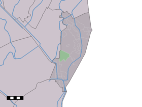
Sellingerbeetse
- Sellingerbeetse
-
Sellingerbeetse est un hameau néerlandais de la province de Groningue.
Le hameau est situé à l'ouest de Sellingen, aux abords d'une petite réserve naturelle, le Sellingerveld. Près du hameau sont situés trois étangs, créés après l'extraction de sable, et de nos jours destinés au tourisme.
Wikimedia Foundation.
2010.
Contenu soumis à la licence CC-BY-SA. Source : Article Sellingerbeetse de Wikipédia en français (auteurs)
Regardez d'autres dictionnaires:
Sellingerbeetse — Dutch town locator maps mun town caption = The village (dark green) and the statistical district (light green) of Sellingerbeetse in the municipality of Vlagtwedde.Sellingerbeetse (coord|52|56|N|7|5|E|type:city(210)) is a town in the Dutch… … Wikipedia
Vlagtwedde — Héraldique … Wikipédia en Français
Vlagtwedde — Infobox Settlement official name = Vlagtwedde mapsize = 280px subdivision type = Country subdivision name = Netherlands subdivision type1 = Province subdivision name1 = Groningen area footnotes = (2006) area total km2 = 170.51 area land km2 = 167 … Wikipedia
Agodorp — 52°52′N 7°5′E / 52.867, 7.083 Agodorp … Wikipédia en Français
Barnflair — 52°51′5″N 7°4′54″E / 52.85139, 7.08167 … Wikipédia en Français
Bourtange — 53° 00′ 24″ N 7° 11′ 30″ E / 53.0067, 7.19167 … Wikipédia en Français
Jipsingboermussel — 53°1′34″N 7°6′42″E / 53.02611, 7.11167 … Wikipédia en Français
Jipsingboertange — 53°1′34″N 7°6′42″E / 53.02611, 7.11167 … Wikipédia en Français
Jipsinghuizen — 52°58′37″N 7°8′59″E / 52.97694, 7.14972 … Wikipédia en Français
Lauderzwarteveen — 52° 55′ 31″ N 7° 06′ 16″ E / 52.9253, 7.10444 … Wikipédia en Français
 Pays-Bas

