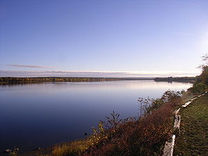
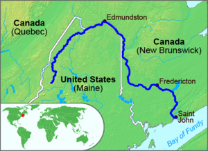
Saint John River
- Saint John River
-
Wikimedia Foundation.
2010.
Contenu soumis à la licence CC-BY-SA. Source : Article Saint John River de Wikipédia en français (auteurs)
Regardez d'autres dictionnaires:
Saint John River — St John River Map.png Daten Gewässerkennzahl … Deutsch Wikipedia
Saint John River — River, northeastern U.S. and southeastern Canada. Rising in northwestern Maine, it flows northeast to the Canadian border, then southeast to form that international boundary; in Canada, it flows through New Brunswick into the Bay of Fundy at… … Universalium
Saint John River — Infobox River | river name = Saint John River caption = The course of the St. John River origin = Northwestern Maine mouth = Bay of Fundy at Saint John, NB basin countries = Canada, United States length = 673 km (418 mi) elevation = 360 m (1,181… … Wikipedia
Saint John River (Afrika) — Saint John River Vorlage:Infobox Fluss/KARTE fehlt DatenVorlage:Infobox Fluss/GK … Deutsch Wikipedia
Saint John River (Begriffsklärung) — Saint John River ist der Name folgender Flüsse: Saint John River, ein Grenzfluss im Osten der Vereinigen Staaten und Kanadas Saint John River (Afrika), ein Fluss in den Republiken Liberia und Guinea Der ähnlich klingende Name St. Johns River… … Deutsch Wikipedia
Saint John River High Level Crossing — The Saint John River High Level Crossing is a steel girder bridge crossing the Saint John River at Coystown, New Brunswick, Canada.Completed in 2001 and opened to the public in October, 2002, the bridge carries 4 lanes of the realigned Route 2… … Wikipedia
Saint John River — noun a river that rises in Maine and flows northeastward through New Brunswick to empty into the Bay of Fundy • Syn: ↑Saint John, ↑St. John, ↑St. John River • Instance Hypernyms: ↑river • Part Holonyms: ↑Maine, ↑ … Useful english dictionary
Northwest Branch Saint John River — Origin Lac Frontière, Quebec Basin countries Canada, United States Length about 13 miles (20 km) Mouth elevation 1,050 feet (320 m) The Northwest … Wikipedia
2008 Saint John River Flood — Infobox flood image location=Saint John River Flood.jpg name=2008 Saint John River Flood duration=April May 2008 total da CDN$ total fatalities=0 areas affected= Edmundston, New Brunswick Fredericton, New Brunswick Fort Kent, Maine Maugerville,… … Wikipedia
List of crossings of the Saint John River — The following bridges and ferries cross the Saint John River in the Canadian province of New Brunswick and U.S. state of Maine … Wikipedia
 Canada
 États-Unis

