Caloosahatchee
- Caloosahatchee
-
26° 31′ 01″ N 82° 01′ 59″ W / 26.51702, -82.03314
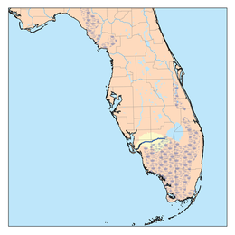
Le Caloosahatchee ((en) Caloosahatchee River) est un fleuve des États-Unis qui prend sa source dans le lac Hicpochee en Floride (lui-même relié au lac Okeechobee par le canal Caloosahatchee). Il draîne la région rurale du nord des Everglades, au nord-ouest de Miami, avant de se jeter dans le Golfe du Mexique. Il est une importante voie fluviale du sud de la Floride dont le cours s'étend sur 121 kilomètres et le bassin sur plus de 3 570 km²[1].
Histoire
Le fleuve doit son nom à la tribu Calusa qui peuplait la région lorsque les espagnols y débarquèrent au XVIe siècle. Son nom signifie « rivière des Calusa »[1].
Voir aussi
Notes et références
Wikimedia Foundation.
2010.
Contenu soumis à la licence CC-BY-SA. Source : Article Caloosahatchee de Wikipédia en français (auteurs)
Regardez d'autres dictionnaires:
Caloosahatchee — steht für Caloosahatchee Kultur, prähistorische indianische Kultur, Florida (500 bis 1750) Caloosahatchee National Wildlife Refuge, Wildreservat in Florida Caloosahatchee Bridge (Hancock Bridge, US 41 Bridge), Brücke in Fort Myers, Florida… … Deutsch Wikipedia
Caloosahatchee — Ca·loo·sa·hatch·ee (kə lo͞o sə hăchʹē) A river of southern Florida, about 120 km (75 mi) long, flowing west from south central Florida to the Gulf of Mexico. It is connected to Lake Okeechobee by the Caloosahatchee Canal and forms the western… … Universalium
Caloosahatchee — Sp Kalùsahačis Ap Caloosahatchee L u. JAV (Florida) … Pasaulio vietovardžiai. Internetinė duomenų bazė
Caloosahatchee — noun a river in southern Florida that flows westerly to the Gulf of Mexico; forms the western end of the Cross Florida Waterway • Syn: ↑Caloosahatchee River • Instance Hypernyms: ↑river • Part Holonyms: ↑Florida, ↑Sunshine State, ↑Eve … Useful english dictionary
Caloosahatchee River — Caloosahatchee Caloosahatchee Caractéristiques Longueur 121 km Bassin 3 570 km2 … Wikipédia en Français
Caloosahatchee-Kultur — ist eine Bezeichnung für eine an der südwestlichen Küste des heutigen Floridas am Golf von Mexiko ansässige prähistorische indianische Kultur. Sie lässt sich für den Zeitraum von etwa 500 bis 1750 nach Christus nachweisen. Das Siedlungsgebiet… … Deutsch Wikipedia
Caloosahatchee culture — The Caloosahatchee culture is an archaeological culture on the southwest Gulf coast of Florida that lasted from about 500 to 1750 CE. Its territory consisted of the coast from Estero Bay to Charlotte Harbor and inland about halfway to Lake… … Wikipedia
Caloosahatchee River — The Caloosahatchee River is a river on the southwest Gulf Coast of Florida in the United States, approximately 75 mi (121 km long). It drains rural area on the northern edge of the Everglades northwest of Miami. An important link in the inland… … Wikipedia
Caloosahatchee Bridge — Infobox Bridge bridge name=Caloosahatchee Bridge caption= official name=Caloosahatchee Bridge carries= crosses=Caloosahatchee River locale=Fort Myers and North Fort Myers, Florida maint= id= design=Girder Bridge mainspan= length= width= height=… … Wikipedia
Caloosahatchee National Wildlife Refuge — Infobox protected area | name = Caloosahatchee National Wildlife Refuge iucn category = V caption = locator x = 225 locator y = 161 location = Lee County, Florida, USA nearest city = Fort Myers, Florida lat degrees = lat minutes = lat seconds =… … Wikipedia
 États-Unis