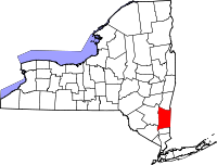
Dutchess County, New York
- Dutchess County, New York
-
Comté de Dutchess
Le comté de Dutchess est situé aux États-Unis dans le sud de l'État de New York. Il forme une partie de la région Grand New York. Selon le recensement de 2000, sa population est de 295 146. Il fut nommé en l'honneur de Marie de Modène, femme du futur Jacques II d'Angleterre, lorsqu'ils furent le duc et le duchesse (dutchess en anglais) de York.
Comtés adjacents
 Portail des États-Unis
Catégorie : Comté de l'État de New York
Wikimedia Foundation.
2010.
Contenu soumis à la licence CC-BY-SA. Source : Article Dutchess County, New York de Wikipédia en français (auteurs)
Regardez d'autres dictionnaires:
Dutchess County, New York — Dutchess redirects here. For other uses, see Dutchess (disambiguation). Dutchess County, New York Location in the state of New York … Wikipedia
County Route 21 (Dutchess County, New York) — County Route 21 is a county route in Dutchess County, New York. It runs from both ends at NY 55. It is known locally as Noxon Road, East Noxon Road, Bruzgul Road, and Wingdale Road as well as Pleasant Ridge Road. It runs through LaGrange,… … Wikipedia
County Route 9 (Dutchess County, New York) — Infobox road state=NY C county=Dutchess route=9 alternate name= length mi=16.4 length round=1 length ref= established= direction a=south starting terminus= junction= direction b=north ending terminus= previous county=Dutchess previous route=8… … Wikipedia
List of county routes in Dutchess County, New York — Dutchess County, New York maintains a system of signed county routes primarily to serve local traffic between the various communities in the county. Route numbers generally increase progressively based on the alphabetical order of the towns where … Wikipedia
National Register of Historic Places listings in Dutchess County, New York — Location of Dutchess County in New York … Wikipedia
Clinton, Dutchess County, New York — For other places named Clinton, New York, see Clinton, New York (disambiguation). Clinton, New York Town … Wikipedia
Chelsea, Dutchess County, New York — Central Chelsea Chelsea is an unincorporated hamlet of the Town of Wappinger in Dutchess County, New York, United States. It is located on the Hudson River in the southwestern corner of the town. It takes the ZIP Code 12512 and is in the 845… … Wikipedia
Fairview, Dutchess County, New York — Fairview is a hamlet (and census designated place) in Dutchess County, New York, United States. The population was 5,421 at the 2000 census.Fairview is a community in the northern part of the Town of Poughkeepsie that borders the northern city… … Wikipedia
Putnam County, New York — Infobox U.S. County county = Putnam County state = New York map size = 250 founded = 1812 seat = Carmel | area total sq mi =246 area land sq mi =231 area water sq mi =15 area percentage = 1.21% census yr = 2000 pop = 95745 density km2 =160 web =… … Wikipedia
Columbia County, New York — There is also a Town of Columbia in New York. Columbia County, New York Seal … Wikipedia

 États-Unis
