- Chesapeake and Ohio Canal
-
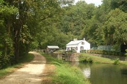
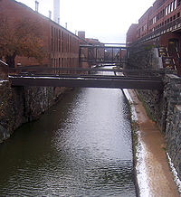
Le Chesapeake and Ohio Canal, abrégé C&O Canal, appelé quelquefois le "Grand Old Ditch" (littéralement le Grand et vieux fossé), est un canal parallèle à la rivière Potomac de Cumberland (Maryland) à Washington, DC.
Il fut en activité de 1836 jusqu'en 1924.
Sa longueur totale est de 300 km (184,5 miles). Sa déclivité du canal est d'environ 185 m (605 ft), franchie par 74 écluses.
La traversée de cours d'eau importants a requis la construction de 11 aqueducs (10 sont encore présents). Le canal passe aussi à travers le Paw Paw Tunnel de 950 m (3120 ft). Le charbon venant des montagnes du comté Allegany était la principale cargaison.
Le canal est dorénavant un parc, le Chesapeake and Ohio Canal National Historical Park. Un parcours de promenade suit le chemin de halage.
Sommaire
Histoire
George Washington a une importance majeure dans sa création. En 1785, il fonde la Compagnie du Potomac en vue d'améliorer la navigabilité sur le Potomac. En 1836, le canal est utilisé en tant qu'axe majeur pour le transport du courrier de Georgetown à Shepherdstown. Le contrat était détenu par Albert Humrickshouse pour $1 000 (740,29€) par an.
La Compagnie du Potomac construit un certain nombre de canaux permettant le contournement des chutes dont le canal du Potomac en Virginie. Une fois terminé, celui-ci permet aux bateaux et aux radeaux d'aller en aval jusqu'à Georgetown. Aller en amont est plus difficile, seuls les bateaux légers peuvent remonter la rivière.
L'achèvement du Canal Érié inquiète les commerçants du sud car leurs affaires pouvaient être menacé par ce canal; les plans pour ce canal reliant l'Ohio et Chesapeake sont élaborés dès 1820.
En 1824, les contrats de la Compagnie du Potomac sont cédés à la Chesapeake and Ohio Company. Benjamin Wright, ancien chef ingénieur du Canal Érié, est nommé chef ingénieur de ces nouveaux travaux, et la construction débute avec une cérémonie d'inauguration le 4 juillet 1828 par le Président John Quincy Adams.
En 1843, le Pont Aqueduc du Potomac est construit près de l'actuel Key Bridge pour relier le Chesapeake and Ohio Canal à l'Alexandria Canal qui mène à Alexandria.
Durant les années 1870, un canal incliné en amont de Georgetown est mis en service, de sorte que les bateaux dont la destination se trouvait en aval de Washington puissent éviter les encombrements de Georgetown. Le plan incliné est démantelé après une inondation importante en 1889 quand la propriété du canal est transféré à la B&O Railroad. Celle-ci continue l'exploitation du canal (en particulier à Point of Rocks) afin de préserver ses droits et empêcher de les voir tomber dans les mains d'autres compagnies de chemin de fer. L'exploitation cesse en 1924 après une autre inondation.
Création du parc national
Le canal abandonné est racheté en 1938 par le gouvernement des États-Unis, qui souhaite en faire une zone de loisirs. Les 35 premiers kilomètres (22 miles) du canal sont alors réparés et remis en eau, mais le projet est arrêté lorsque les États-Unis entrent en guerre, les ressources étant nécessaires ailleurs. Après la guerre, le Congrès envisage de transformer le canal et le chemin de halage en autoroute. Cependant cette idée est rejetée par certains, dont le membre de la Cour suprême des États-Unis, le Juge Associé William O. Douglas.
En mars 1954, Douglas effectue une randonnée de 8 jours le long du chemin de halage de Cumberland à Washington D.C. Bien que 58 personnes participent à la marche, seulement 6 hommes, dont Douglas, font la totalité des 297 km (184 miles). La mobilisation populaire et la couverture médiatique de cette marche font rejeter l'idée d'autoroute, et le 8 janvier 1971, le canal devint un parc historique national.
Actuellement le parc s'étend sur près de 80 km² (20 000 acres) et reçoit plus de 3 millions de visiteurs chaque année. Les inondations continuent de menacer les structures historiques du canal mais il y a des tentatives de restauration. Les services techniques ont remis en eau certaines parties mais la majorité du canal est à sec.
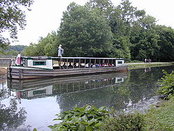
Aujourd'hui, le canal est une promenade populaire pour les résidents de Washington. Le chemin de halage est fréquenté par les cyclistes et les joggers. La pêche et la navigation de plaisance sont pratiquées dans les zones remises en eau. Les kayakistes qui luttent contre les rapides du Potomac utilisent aussi quelquefois le canal comme relais. Le parc propose des balades sur deux reproductions de bateaux ayant navigués sur le canal. Les bateaux sont tirés par des mules et manœuvrés par les rangers du parc en tenu d'époque
Écluses sur le canal
Article détaillé : Écluses du Chesapeake and Ohio Canal.Points d'Intérêt du canal par les marqueurs de Mile
- Mile 000: Rock Creek Park
- Mile 000: Potomac Heritage Trail - du côté de la rivière en Virginie. (Les vélos peuvent l'utiliser après Key Bridge.)
- Mile 000: C&O Canal Monument
- Mile 000: Capital Crescent Trail
- Mile 000: Georgetown (Washington, D.C.)
- Mile 003: Fletchers Boathouse
- Mile 004: Pimmit Run Trail
- Mile 006: Sycamore Island
- Mile 007: Glen Echo Park (Maryland)
- Mile 012: Old Angler's Inn
- Mile 012: Rockwood Manor Park
- Mile 014: Billy Goat Trail dans le Great Fall Park
- Mile 014: Great Falls Park
- Mile 020: Pennyfield Lock
- Mile 022: Violette’s Lock (Lock 23)
- Mile 022: Seneca Creek
- Mile 026: Dierssen Wildlife Management Area & McKee-Beshers Wildlife Management Area
- Mile 035: Poolesville (Maryland)
- Mile 035: Norris House Bed and Breakfast
- Mile 042: Monocacy Aqueduct
- Mile 048: Point of Rocks (Maryland)
- Mile 055: Brunswick (Maryland)
- Mile 055: Beans in the Belfry
- Mile 058: Sentier des Appalaches
- Mile 059: Harpers Ferry Hostel
- Mile 059: River and Trail Outfitters
- Mile 060: Harpers Ferry (Virginie-Occidentale)
- Mile 073: Ferry Hill (Virginie Occidentale)
- Mile 073: Shepherdstown (Virginie Occidentale)
- Mile 073: Sharpsburg (Maryland) - Jacob Rohrbach Inn
- Mile 073: Sharpsburg (Maryland) - Antietam National Battlefield
- Mile 080: Shepherd's Spring Outdoor Ministries Center
- Mile 100: Williamsport Canal Visitor Center
- Mile 112: Fort Frederick State Park; Western Maryland Rail Trail begins
- Mile 124: Hancock (Maryland)
- Mile 124: Cohill Manor Bed and Breakfast
- Mile 124; Tonoloway Lodge
- Mile 124: Buck Valley Ranch
- Mile 124: Rt. 522 Bridge à Berkeley Springs (Virginie Occidentale); Western Maryland Rail Trail
- Mile 140: Town Hill Hotel B&B
- Mile 140: Little Orleans (Maryland)
- Mile 141: Little Orleans Lodge
- Mile 143: Green Ridge Hiking Trails
- Mile 151: Paw Paw Tunnel
- Mile 151: the Heritage Trail Bed & Breakfast
- Mile 151: Paw Paw (Virginie Occidentale)
- Mile 161: Oldtown (Maryland)
- Mile 184: Cumberland (Maryland)
- Mile 184: The Inn at Walnut Bottom
- Mile 184: Canal Place
- Mile 184: Hites Bike Shop
- Mile 184: Western Maryland Scenic Railroad
- Mile 184: Alleghany Trail Alliance
Sources
- (en) Cet article est partiellement ou en totalité issu de l’article de Wikipédia en anglais intitulé « Chesapeake and Ohio Canal » (voir la liste des auteurs)
Références
Bibliographie
- Life on the Chesapeake & Ohio Canal, 1859
- Achenbach, Joel. The Grand Idea: George Washington's Potomac and the Race to the West, Simon and Schuster, 2004.
- Blackford, John, 1771-1839. Ferry Hill Plantation journal: life on the Potomac River and the Chesapeake and Ohio Canal, 4 January 1838-15 January 1839
- Camagna, Dorothy. The C&O Canal: From Great National Project to National Historical Park, Belshore Publications, 2005.
- C and O Canal Association. Food and Lodging along the Towpath.
- Cotton, Robert. The Chesapeake and Ohio Canal Through the Lens of Sir Robert Cotton
- Fradin, Morris. Hey-ey-ey, lock! 1974
- Furtney, Charles Tyrconnel: An Antebellum Adventure Along the C&O Canal
- Gutheim, Frederick. The Potomac. New York: Rinehart and Co., 1949.
- Hahn, Thomas F. The Chesapeake and Ohio Canal Lock-Houses and Lock-Keepers (ISBN 1-885907-03-6).
- Hahn, Thomas F. The Chesapeake and Ohio Canal: Pathway to the Nation's Capital. Metuchen, NJ: The Scarecrow Press, 1984.
- Hahn, Thomas F. Towpath Guide to the C&O Canal: Georgetown Tidelock to Cumberland. Shepherdstown, WV: American Canal and Transportation Center, 1985.
- High, Mike. The C&O Canal Companion, Journal de l'Université Johns Hopkins, 2001.
- Kapsch, Robert and Kapsch, Elizabeth Perry. Monocacy Aqueduct on the Chesapeake and Ohio Canal. Medley Press, 2005.
- Kytle, Elizabeth. Home on the Canal, Cabin John, Md.: Seven Locks Press, c. 1983.
- Mackintosh, Barry. C & O Canal: the making of a park Washington, Ministère de l'intérieur des Etats-Unis, Service des parcs nationaux, Division Histoire, 1991.
- Martin, Edwin. A Beginner's Guide to Wildflowers of the C and O Towpath, 1984.
- Mason-Dixon Council, Scouts d'Amérique, 184 Miles of Adventure: Hiker's Guide to the C&O Canal. P.O. Box 2133, Hagerstown, MD 21742, 1983.
- Mulligan, Kate. Canal Parks, Museums and Characters of the Mid-Atlantic, Wakefield Press, Washington D.C., 1999.
- Reeder, Carolyn. Captain Kate. Avon Books, 1999
- Sabatke, Mark. Discovering the C&O Canal, Rockville, Schreiber Publishing, March 2003.
- Ward, George W. The Early Development of the Chesapeake and Ohio Canal Project
- Winslow, Barbara. Samantha goes to Georgetown on the C & O Canal
- Wolfe, George "Hooper." I Drove Mules on the C and O Canal, 1969.
Liens externes
Catégories :- Canal des États-Unis
- Canal du XIXe siècle
Wikimedia Foundation. 2010.


