Cross-Florida Barge Canal
- Cross-Florida Barge Canal
-
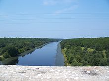
L'une des deux sections du canal, depuis le pont de la SR 19 au sud de Palatka.
Le Cross Florida Barge Canal était un projet de canal devant relier le golfe du Mexique à l'océan Atlantique via la Floride pour le trafic des barges. Bien que deux sections aient effectivement été aménagées, le projet fut finalement abandonné pour les raisons environnementales. Il s'agit aujourd'hui d'une voie verte de 1,6 km de large à certains endroits et baptisé en l'honneur d'une opposante au projet, Marjorie Harris Carr Cross Florida Greenway.
Notes et références
Voir aussi
Articles connexes
Wikimedia Foundation.
2010.
Contenu soumis à la licence CC-BY-SA. Source : Article Cross-Florida Barge Canal de Wikipédia en français (auteurs)
Regardez d'autres dictionnaires:
Cross Florida Barge Canal — One of the two completed sections of the Barge Canal, looking west from the SR 19 bridge south of Palatka … Wikipedia
Barge Canal — (Florida) may refer to one of two projects:*Merritt Island Barge Canal, in Brevard County, Florida *Cross Florida Barge Canal, a never completed project to connect the St. Johns River to the Gulf of Mexico … Wikipedia
Canaveral Barge Canal — Barge canal, looking towards the Christa McAuliffe Bridge Date of first use January 1, 1965 Locks 1 … Wikipedia
Florida National Cemetery — is a United States National Cemetery located in the city of Bushnell in Sumter County, Florida .Florida National Cemetery is located in the Withlacoochee State Forest, approximately 50 miles north of Tampa in Sumter County, Fla. Withlacoochee… … Wikipedia
Florida Museum of Natural History — Coordinates: 29°38′09″N 82°22′13″W / 29.63583°N 82.37028°W / 29.63583; 82.37028 … Wikipedia
Florida State Road 40 — State Road 40 Route information Maintained by FDOT Length: 91.7 mi[ … Wikipedia
Florida Railroad — The Florida Railroad was the first railroad to connect the east and west coasts of Florida, running from Fernandina to Cedar Key. The line later became part of the Seaboard Air Line Railroad, and, where still in use, is operated by CSX… … Wikipedia
Florida State Road 19 — Infobox road state=FL type= route=19 length mi=89.0 length round=2 length ref=cite web |url=http://www.dot.state.fl.us/planning/statistics/gis/default.htm |title=FDOT GIS data |accessmonthday=June 27 |accessyear=2007 |author=Florida Department of … Wikipedia
U.S. Route 441 in Florida — This article is about the section of U.S. Route 441 in Florida. For the entire length of the highway, see U.S. Route 441. U.S. Highway 441 … Wikipedia
Haulover Canal — Date completed 1887 Status Open Navigation authority U.S. Army Corps of Engineers The Haulover Canal is a waterway north of Merritt Island, Florida, near the former site of Allenhurst, that connects Mosquito Lagoon with the Indian River, and is… … Wikipedia

