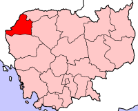
Bântéay Méanchey
- Bântéay Méanchey
-
Banteay Mean Chey
|
បន្ទាយមានជ
Banteay Mean Chey |
|
|
| Pays |
 Cambodge Cambodge |
| Capitale |
Sisophon |
| Superficie |
6 679 km² |
| Population |
577 772 (1998) |
| Densité |
86,5 hab./km² |
| ISO 3166-2 |
KH-1 |
 |
Banteay Mean Chey ("forteresse victorieuse" en khmer, chey est issu du sanskrit jaya : "victoire") est une province du Cambodge. Elle comprend 8 districts :
- 0102 Mongkol Borei ("ville auspicieuse")
- 0103 Phnum Srok ("colline du village")
- 0104 Preah Netr Preah ("yeux du seigneur", nom lié à une légende)
- 0105 Ou Chrov ("rigole profonde")
- 0106 Serei Saophoan (Sisophon, "glorieuse et auspicieuse")
- 0107 Thma Puok ("pierre du groupe de travailleurs" ou "pierre effritée")
- 0108 Svay Chek ("manguiers et bananes")
- 0109 Malai ("des monts Malaya, au Sud-Ouest de l'Inde")
Bibliographie
- Lewitz, S., La toponymie khmère, BEFEO (Bulletin de l'École française d'Extrême-Orient) 53, 2, 1967, pp. 377-450.
- Lewitz, S., Martel, G. et Vidal, J.-E., Notes ethnobotaniques sur quelques plantes en usage au Cambodge, BEFEO 55, 1969, pp. 171-232.
- Lewitz, S. et Rollet, B., Lexique des noms d’arbres et d’arbustes au Cambodge, BEFEO 60, 1973, pp. 113-162.
- Pou, S., Dictionnaire vieux khmer-français-anglais. An Old Khmer-French-English Dictionary, L'Harmattan, 2004, 2e édition augmentée, 732 p.
 Portail du Cambodge
Catégorie : Province du Cambodge
Wikimedia Foundation.
2010.
Contenu soumis à la licence CC-BY-SA. Source : Article Bântéay Méanchey de Wikipédia en français (auteurs)
Regardez d'autres dictionnaires:
Banteay Meanchey — Kurzübersicht Hauptstadt Sisophon Fläche 6.679 … Deutsch Wikipedia
Banteay Meanchey Province — Infobox Cambodian Province name = Banteay Meanchey khmer = បន្ទាយមានជ័យ area = 6,679 population = 577,772 population as of = 1998 density = 86.5 isocode = KH 1 capital = Sisophon districts = 8 communes = 64 villages = 624 | map Banteay Meanchey… … Wikipedia
Banteay Meanchey Province — Admin ASC 1 Code Orig. name Banteay Meanchey Province Country and Admin Code KH.25 KH … World countries Adminstrative division ASC I-II
Samraong, Banteay Meanchey (commune) — Infobox Commune Cambodia name= Samraong khmer= province=Banteay Meanchey district= Ou Chrov District population= population as of=1998 villages=10 geocode= Samraong is a khum (commune) of Ou Chrov District in Banteay Meanchey Province in north… … Wikipedia
Kampong Svay, Banteay Meanchey — for other uses see Kampong Svay Infobox Commune Cambodia name= Kampong Svay khmer= province=Banteay Meanchey district= Serei Saophoan District population= population as of=1998 communes= villages=5 geocode= Kampong Svay is a khum (commune) of… … Wikipedia
Banteay Meancheay — Banteay Meanchey Kurzübersicht Hauptstadt Sisophon Fläche 6.679 km² Bevölkerung … Deutsch Wikipedia
Meanchey District — is located in the southeastern part of Phnom Penh, Cambodia. The district is subdivided into 8 Sangkats and 30 Kroms. The district has an area of 43.79 km². According to the 1998 census of Cambodia, it had a population of 157,112.[1] Postal… … Wikipedia
Banteay Chhmar — Infobox Commune Cambodia name=Banteay Chhmar khmer= province=Banteay Meanchey district= Serei Saophoan District population= population as of=1998 communes= villages=14 geocode= Banteay Chhmar is a commune (khum) and a large temple complex in in… … Wikipedia
Banteay Neang — Infobox Commune Cambodia name=Banteay Neang khmer= province=Banteay Meanchey district= Mongkol Borei District population= population as of=1998 communes= villages=18 geocode=010201 Banteay Neang is a khum (commune) of Mongkol Borei District in… … Wikipedia
Banteay Chhmar — 14.071111111111103.10916666667 Koordinaten: 14° 4′ N, 103° 7′ O … Deutsch Wikipedia
 Cambodge
