Bobeldijk
Contenu soumis à la licence CC-BY-SA. Source : Article Bobeldijk de Wikipédia en français (auteurs)
Regardez d'autres dictionnaires:
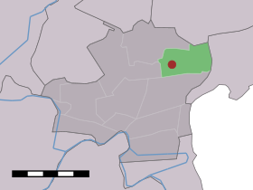
Bobeldijk — Dutch town locator maps mun town caption = The village (dark red) and the statistical district (light green) of Bobeldijk in the municipality of Wester Koggenland.Bobeldijk (coord|52|39|N|5|0|E|type:city(300)) is a town in the Dutch province of… … Wikipedia
Hoorn — Infobox Settlement official name = Hoorn mapsize = 280px flag size = 150x75px image shield = Hoorn wapen.png shield size = 150x75px subdivision type = Country subdivision name = Netherlands subdivision type1 = Province subdivision name1 = North… … Wikipedia
List of places in the Netherlands — This is an alphabetical list of places (cities, towns, villages) in the Netherlands. Lists per province can be found at:* List of towns in Groningen * List of towns in Friesland * List of towns in Drente * List of towns in Overijssel * List of… … Wikipedia
BMI1 — polycomb ring finger oncogene, also known as BMI1, is a human gene. PBB Summary section title = summary text = PBB Further reading citations = *cite journal | author=Alkema MJ, van der Lugt NM, Bobeldijk RC, et al. |title=Transformation of axial… … Wikipedia
Koggenland — Gemeinde Koggenland Flagge Wappen Provinz Nordholland Bürgermeister … Deutsch Wikipedia
Wester-Koggenland — Gemeinde Wester Koggenland Flagge Wappen Provinz Nordholland … Deutsch Wikipedia
Avenhorn — 52°37′12″N 4°57′15″E / 52.62, 4.95417 … Wikipédia en Français
Berkhout — 52°38′31″N 4°59′49″E / 52.64194, 4.99694 … Wikipédia en Français
De Goorn — 52°37′49″N 4°56′40″E / 52.63028, 4.94444 … Wikipédia en Français
Grosthuizen — 52° 37′ 00″ N 4° 59′ 00″ E / 52.6167, 4.98333 … Wikipédia en Français
 Pays-Bas