Spierdijk
Contenu soumis à la licence CC-BY-SA. Source : Article Spierdijk de Wikipédia en français (auteurs)
Regardez d'autres dictionnaires:
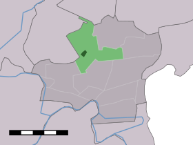
Spierdijk — Dutch town locator maps mun town caption = The town centre (dark green) and the statistical district (light green) of Spierdijk in the municipality of Koggenland.Spierdijk (coord|52|39|N|4|57|E|type:city(554)) is a town in the Dutch province of… … Wikipedia
Wogmeer — 52°39′28″N 4°55′32″E / 52.65778, 4.92556 … Wikipédia en Français
Koggenland — Gemeinde Koggenland Flagge Wappen Provinz Nordholland Bürgermeister … Deutsch Wikipedia
Wester-Koggenland — Gemeinde Wester Koggenland Flagge Wappen Provinz Nordholland … Deutsch Wikipedia
Avenhorn — 52°37′12″N 4°57′15″E / 52.62, 4.95417 … Wikipédia en Français
Berkhout — 52°38′31″N 4°59′49″E / 52.64194, 4.99694 … Wikipédia en Français
Bobeldijk — 52°39′56″N 4°58′33″E / 52.66556, 4.97583 … Wikipédia en Français
De Goorn — 52°37′49″N 4°56′40″E / 52.63028, 4.94444 … Wikipédia en Français
Grosthuizen — 52° 37′ 00″ N 4° 59′ 00″ E / 52.6167, 4.98333 … Wikipédia en Français
Hensbroek — 52°39′31″N 4°53′11″E / 52.65861, 4.88639 … Wikipédia en Français
 Pays-Bas