Zuidermeer
Contenu soumis à la licence CC-BY-SA. Source : Article Zuidermeer de Wikipédia en français (auteurs)
Regardez d'autres dictionnaires:
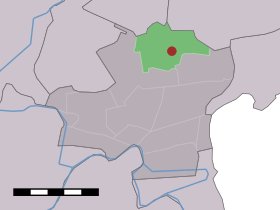
Zuidermeer — Dutch town locator maps mun town caption = The village (dark red) and the statistical district (light green) of Zuidermeer in the municipality of Wester Koggenland.Zuidermeer (coord|52|40|N|4|59|E|type:city(480)) is a town in the Dutch province… … Wikipedia
Bed & Breakfast De Koegang — (Zuidermeer,Нидерланды) Категория отеля: Адрес: Noordermeer 10a, 1652 PD … Каталог отелей
Wogmeer — 52°39′28″N 4°55′32″E / 52.65778, 4.92556 … Wikipédia en Français
Wester-Koggenland — Infobox Settlement name =PAGENAME official name = other name = native name = nickname = settlement type = total type = motto = imagesize = image caption = flag size = image seal size = image shield = shield size = image blank emblem = blank… … Wikipedia
List of places in the Netherlands — This is an alphabetical list of places (cities, towns, villages) in the Netherlands. Lists per province can be found at:* List of towns in Groningen * List of towns in Friesland * List of towns in Drente * List of towns in Overijssel * List of… … Wikipedia
Koggenland — Gemeinde Koggenland Flagge Wappen Provinz Nordholland Bürgermeister … Deutsch Wikipedia
Wester-Koggenland — Gemeinde Wester Koggenland Flagge Wappen Provinz Nordholland … Deutsch Wikipedia
Avenhorn — 52°37′12″N 4°57′15″E / 52.62, 4.95417 … Wikipédia en Français
Berkhout — 52°38′31″N 4°59′49″E / 52.64194, 4.99694 … Wikipédia en Français
Bobeldijk — 52°39′56″N 4°58′33″E / 52.66556, 4.97583 … Wikipédia en Français
 Pays-Bas