Čierny Balog

Čierny Balog
Čierny Balog
(Village)
Blason de Čierny Balog
Héraldique

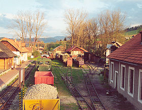
Gare du chemin de fer forestier Čiernohronská železnica
Administration
Pays Drapeau de Slovaquie Slovaquie
Région Région de Banská Bystrica
District District de Brezno
Code postal 976 52
Plaque minéralogique BR
Starosta (maire) František Budovec ( Indépendant )

Mandat: 2013

Démographie
Population 5 144 hab. (31.12.2007)
Densité 35 hab./km2
Géographie
Coordonnées 48° 44′ 53″ Nord
       19° 39′ 04″ Est
/ 48.748056, 19.651111
Altitude 555 m
Superficie 14 710,427 ha = 147,10427 km²
Localisation en Slovaquie
Voir la carte physique
Localisation de la ville
Čierny Balog
Voir la carte administrative
Localisation de la ville
Čierny Balog
Localisation dans la région de Banská Bystrica
Voir la carte physique
Localisation de la ville
Čierny Balog
Voir la carte administrative
Localisation de la ville
Čierny Balog
Internet
Site de la commune http://www.ciernybalog.sk
Sources
Resultat des élections
http://www.e-obce.sk [1]
http://www.statistics.sk [2]

Čierny Balog (allemand : Schwarzseifen ,hongrois : Feketebalog) est un village de Slovaquie situé dans la région de Banská Bystrica.

Histoire

Première mention écrite du village en 1863.

Patrimoine

Un chemin de fer forestier à écartement étroit 760 mm le Čiernohronská železnica passe par le village.

Notes et références


Wikimedia Foundation. 2010.

Contenu soumis à la licence CC-BY-SA. Source : Article Čierny Balog de Wikipédia en français (auteurs)

Игры ⚽ Поможем написать курсовую

Regardez d'autres dictionnaires:

  • Cierny Balog — Čierny Balog Wappen Karte …   Deutsch Wikipedia

  • Čierny Balog — Wappen Karte …   Deutsch Wikipedia

  • Čierny Balog — Coordinates: 48°45′N 19°40′E / 48.75°N 19.667°E / 48.75; 19.667 …   Wikipedia

  • Cierny Balog — Original name in latin ierny Balog Name in other language Cierny Balog, Cierny Balok, Cierny Blh, ierny Balog, ierny Balok, ierny Blh State code SK Continent/City Europe/Bratislava longitude 48.74722 latitude 19.65125 altitude 530 Population 5234 …   Cities with a population over 1000 database

  • Čierny Balog — Sp Čièrni Bãlogas Ap Čierny Balog L Slovakija …   Pasaulio vietovardžiai. Internetinė duomenų bazė

  • Apartmány Čierny Balog — (Čierny Balog,Словакия) Категория отеля: Адрес: Medveďovo 2210, 97652 Čierny …   Каталог отелей

  • Čierny Hron Railway — A train is prepaired to travel from Hronec to Čierny Balog. The Čierny Hron Railway (in Slovak: Čiernohronská železnica or ČHŽ) is a narrow gauge railway in the Slovak Ore Mountains, built as an industrial railway for logging operations. History… …   Wikipedia

  • Čiernohronská železnica — Vydrovo dolina–Chvatimech Kursbuchstrecke: ZSSK: 900 Streckenlänge: 16 km Spurweite: 760 mm (Bosnische Spur) …   Deutsch Wikipedia

  • Schwarzgranbahn — Vydrovo dolina–Chvatimech Kursbuchstrecke: ZSSK: 900 Streckenlänge: 16 km Spurweite: 760 mm (Bosnische Spur) …   Deutsch Wikipedia

  • Liste der Städte und Gemeinden in der Slowakei/A-G — Übersicht A bis G Teil 1 A bis G Teil 2 H bis Ľ Teil 3 M bis R Teil 4 S bis Ž Übersicht A B C Č D Ď E F G A …   Deutsch Wikipedia

Share the article and excerpts

Direct link
Do a right-click on the link above
and select “Copy Link”