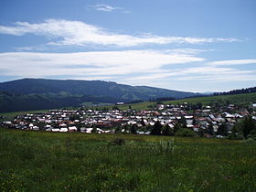
Bacúch
Contenu soumis à la licence CC-BY-SA. Source : Article Bacúch de Wikipédia en français (auteurs)
Regardez d'autres dictionnaires:
Bacúch — ( de. Batzuch, Watzuch; hu. Vacok) is a village and municipality in Brezno District, in the Banská Bystrica Region of Slovakia.HistoryIn historical records the village was first mentioned in 1563 such as a part of the mine district of Brezno. It… … Wikipedia
Apartment Bacúch — (Bacúch,Словакия) Категория отеля: Адрес: 97664 Bacúch, Словакия … Каталог отелей
Chata pod Lipou — (Bacúch,Словакия) Категория отеля: Адрес: Hlavná 242, 97664 Bacúch, Словакия … Каталог отелей
Banská Bystrica Region — Geobox | Region name = Banská Bystrica other name = category = Region image caption = image caption = symbol = symbol type = Coat of arms etymology = official name = motto = nickname = country = Slovakia country state = region = district =… … Wikipedia
Brezno District — Infobox Slovak district subject name = Brezno District slovak region = Banská Bystrica Region population = 65,785 (2001) prefix = 48 area = 1265 car plate = BR image location = Okres brezno.png Brezno District ( okres Brezno ) is a district inthe … Wikipedia
Čierny Balog — Coordinates: 48°45′N 19°40′E / 48.75°N 19.667°E / 48.75; 19.667 … Wikipedia
Dolná Lehota — Location of Brezno District in the Banská Bystrica Region Dolná Lehota (earlier Dolná Lehôtka, Hungarian: Alsószabadi, before 1907 Alsólehota) is a village and municipality in Brezno District, in the Banská Bystrica Region of central Slovakia … Wikipedia
Drábsko — Location of Brezno District in the Banská Bystrica Region Drábsko (Hungarian: Darabos, Drabszkó) is a village and municipality in Brezno District, in the Banská Bystrica Region of central Slovakia. History Set in the highland plateau, it was … Wikipedia
Michalová — Coordinates: 48°46′N 19°47′E / 48.767°N 19.783°E / 48.767; 19.783 … Wikipedia
Mýto pod Ďumbierom — Coordinates: 48°51′N 19°38′E / 48.85°N 19.633°E / 48.85; 19.633 … Wikipedia
 Slovaquie
 Bacúch


