Čierny Brod

Čierny Brod
Čierny Brod
(Village)
Administration
Pays Drapeau de Slovaquie Slovaquie
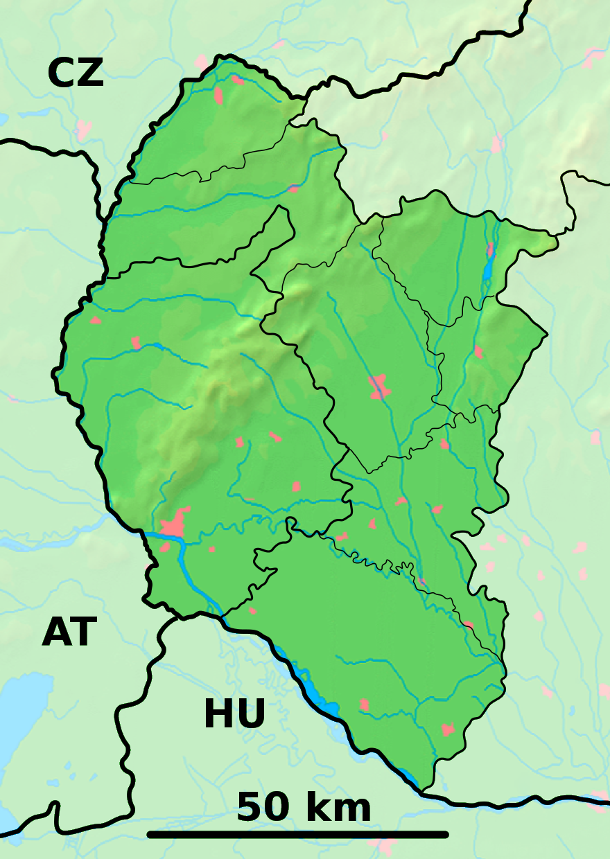
Région Région de Trnava
District District de Galanta
Code postal 925 08
Plaque minéralogique GA
Starosta (maire) Pavel Nagy ( Indépendant )

Mandat: 2013

Démographie
Population 1 577 hab. (31.12.2007)
Densité 89,1 hab./km2
Géographie
Coordonnées 48° 09′ 00″ Nord
       17° 39′ 34″ Est
/ 48.15, 17.659444
Altitude 118 m
Superficie 1 769,8561 ha = 17,698561 km²
Localisation en Slovaquie
Voir la carte physique
Localisation de la ville
Čierny Brod
Voir la carte administrative
Localisation de la ville
Čierny Brod
Localisation dans la région de Trnava
Voir la carte physique
Localisation de la ville
Čierny Brod
Voir la carte administrative
Localisation de la ville
Čierny Brod
Internet
Site de la commune http://www.ciernybrod.sk
Sources
Resultat des élections
http://www.e-obce.sk[1]
http://www.statistics.sk[2]

Čierny Brodhongrois : Vízkelet + Hegy) est un village de Slovaquie situé dans la région de Trnava.

Histoire

Première mention écrite du village en 1223.

La localité fut annexée par la Hongrie après le premier arbitrage de Vienne le 2 novembre 1938. En 1938, on comptait 1331 habitants dont 16 juifs. Elle faisait partie du district de Galanta, en hongrois Galántai járás. Le nom de la localité avant la Seconde Guerre mondiale était Vizkelet. Durant la période 1938 -1945, le nom hongrois Vízkelet était d'usage[3].

Le hameau de Heď était une commune autonome en 1938. Il comptait 283 habitants en 1938 dont 4 juifs. Elle faisait partie du district de Galanta, en hongrois Galántai járás. Le nom de la localité avant la Seconde Guerre mondiale était Hegy. Durant la période 1938 -1945, le nom hongrois Hegy était d'usage[3].

Notes et références


Wikimedia Foundation. 2010.

Contenu soumis à la licence CC-BY-SA. Source : Article Čierny Brod de Wikipédia en français (auteurs)

Игры ⚽ Нужно решить контрольную?

Regardez d'autres dictionnaires:

  • Čierny Brod — Location of Galanta District in the Trnava Region Čierny Brod (Hungarian: Vízkelet) is a village and municipality in Galanta District of the Trnava Region of south west Slovakia. History …   Wikipedia

  • Brod — (slawisch für Furt) ist ein häufiger Ortsname und steht für: Brod nad Dyjí (Guldenfurt), Gemeinde im Okres Břeclav, Tschechien Brod nad Tichou (Bruck am Hammer), Gemeinde im Okres Tachov, Tschechien Brod (Prode), Ortsteil von Heřmanice nad Labem …   Deutsch Wikipedia

  • Brod — is a common Slavic toponym, meaning ford. It may refer to the following:In Croatia: * Slavonski Brod, a city in Croatia. * Brod na Kupi, a small town in the Brod Moravice region in the west part of Croatia. * Brod Posavina County, a county in… …   Wikipedia

  • Kráľov Brod — Wappen Karte …   Deutsch Wikipedia

  • Kráľov Brod — (Village) Administration Pays  Slovaquie …   Wikipédia en Français

  • List of municipalities and towns in Slovakia — Slovakia This is a comprehensive list of municipalities and towns in Slovakia. For lists of towns and municipalities sorted by Regions see the individual articles on Regions. For an outdated list of towns only in Slovakia see also List of towns… …   Wikipedia

  • Galanta District —   District   Country Slovakia …   Wikipedia

  • Liste der Städte und Gemeinden in der Slowakei/A-G — Übersicht A bis G Teil 1 A bis G Teil 2 H bis Ľ Teil 3 M bis R Teil 4 S bis Ž Übersicht A B C Č D Ď E F G A …   Deutsch Wikipedia

  • Liste der Städte und Gemeinden in der Slowakei Teil 1 — Übersicht A bis G Teil 1 A bis G Teil 2 H bis Ľ Teil 3 M bis R Teil 4 S bis Ž Übersicht A B C Č D Ď E F G A …   Deutsch Wikipedia

  • Trnava Region — Geobox | Region name = Trnava category = Region image caption = image caption = symbol = symbol type = etymology = official name = motto = nickname = country = Slovakia country state = region = district = commune = municipality = border = part… …   Wikipedia

Share the article and excerpts

Direct link
Do a right-click on the link above
and select “Copy Link”