Unterrothorn
- Unterrothorn
-
L'Unterrothorn est une montagne du canton du Valais, en Suisse, culminant à 3 104 mètres d'altitude et surplombant la station de Zermatt, à environ 5 km à l’est.
Panorama
Le panorama, hormis le mont Cervin, comprend la Dent Blanche, le mont Rose, le Weisshorn et le massif des Mischabels.
Activités
Remontées mécaniques
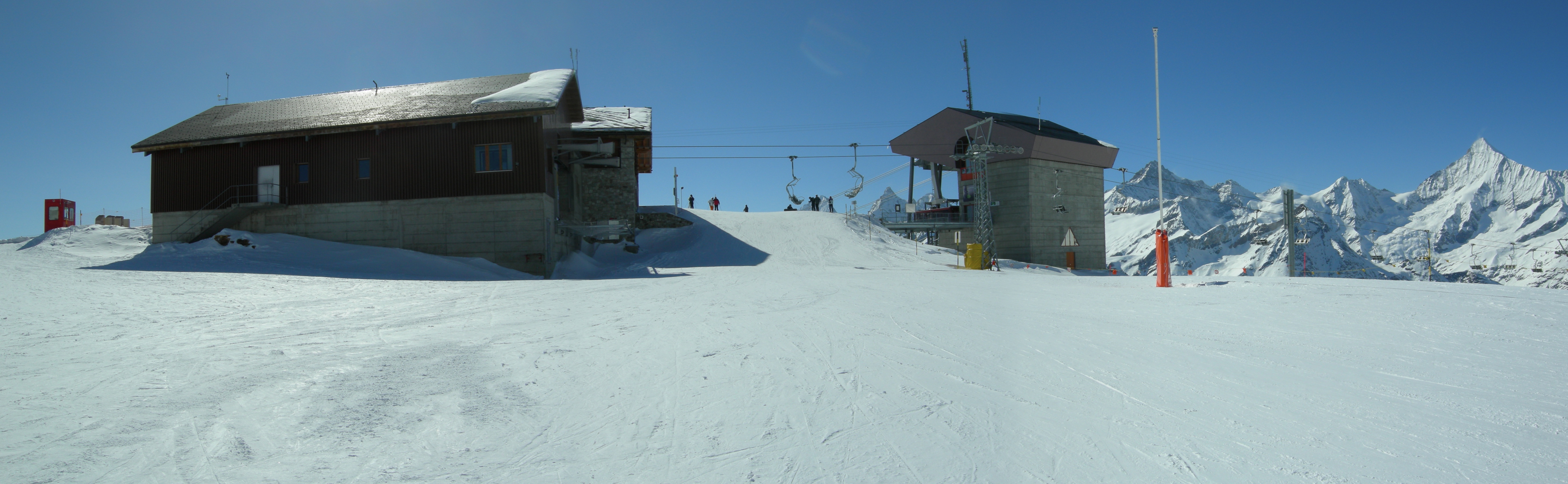
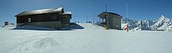
Le sommet est accessible depuis Zermatt, soit par un funiculaire souterrain, le métro, qui rejoint ses contreforts Sunnegga et Blauherd, suivi d’un télécabine, soit respectivement par un téléphérique, ou depuis le lieu-dit Kumme par un télésiège.
Au sommet se trouvent un petit restaurant jouxtant le lieu d’arrivée ainsi qu’une petite station météorologique. Aussi le Unterrothorn est accessible été comme hiver pour le tourisme.
Domaine skiable
L'Unterrothorn constitue le point culminant du domaine skiable Zermatt-Rothorn. De nombreuses pistes de ski de difficultés variables descendent jusqu’à la station.
Alpinisme
C’est également un point de départ pour des tours de haute montagne en direction des sommets Rimpfischhorn, Strahlhorn, Cima di Jazzi ainsi que l'Oberrothorn (3 414 m).
Liens externes
Wikimedia Foundation.
2010.
Contenu soumis à la licence CC-BY-SA. Source : Article Unterrothorn de Wikipédia en français (auteurs)
Regardez d'autres dictionnaires:
Unterrothorn — Blick nach West mit Zinalrothorn und ganz rechts Weisshorn Höhe … Deutsch Wikipedia
Unterrothorn — Infobox Mountain Name = Unterrothorn Photo = Elevation = convert|3101|m|ft|0 Location = Switzerland Range = Pennine Alps Prominence= latd= 46|latm=1 |lats=19 |latNS=N longd=7 |longm=47 |longs=51 |longEW=E pushpin Coordinates =… … Wikipedia
Blauherd — ist eine Alp im Kanton Wallis, die ungefähr 4 km östlich von Zermatt auf einer Höhe von 2580 m liegt. Blauherd liegt über der Baumgrenze auf einer Sonnenterrasse, welche auch die weiter unten liegende Alp Sunnegga beinhaltet. Östlich von… … Deutsch Wikipedia
Matterhorn — Monte Cervino redirects here. For other uses, see Cervino (disambiguation). For other uses, see Matterhorn (disambiguation). Matterhorn Monte Cervino T … Wikipedia
Oberrothorn — Oberrothorn … Wikipedia
Rothorn — The name Rothorn comes from German: Red Peak and may refer to:*Brienzer Rothorn (2350 m), on the border of the cantons of Berne, Lucerne, Obwalden*Canton of Berne **Sigriswiler Rothorn (2051 m), above Lake Thun **Diemtigtaler Rothorn west of… … Wikipedia
Rothorn — ist der Name folgender Berge: in Österreich: Rothorn (Lechquellengebirge), (2.239 m ü. A.), im Lechquellengebirge Rothornspitze (2.393 m ü. A.), in den Allgäuer Alpen in der Schweiz: Diemtigtaler Rothorn (2… … Deutsch Wikipedia
Sunnegga — Blick vom Breitboden auf Findeln und Sunnegga. Sunnegga ist ein Alpgebiet im Kanton Wallis, ca. 2 km östlich von Zermatt gelegen. Sunnegga, welches im Zermatter Touristenjargon Sunnegga paradise genannt wird, liegt auf 2280 m auf einer… … Deutsch Wikipedia
Zermatt Bergbahnen — Les remontées mécaniques de Zermatt sont célèbres surtout grâce à deux installations: le train à crémaillère du Gornergrat (Gornergrat Bahn), et le plus haut téléphérique d Europe, le Petit Cervin, qui culmine à 3883 m. De là, on a une vue… … Wikipédia en Français
Cervino — Matterhorn Caras este y norte del Cervino, separadas por la arista Hörnli … Wikipedia Español
 Suisse