Semanín
Contenu soumis à la licence CC-BY-SA. Source : Article Semanín de Wikipédia en français (auteurs)
Regardez d'autres dictionnaires:
SEMANÎN — Seksen. 80 … Yeni Lügat Türkçe Sözlük
Şİ'RA-ÜL YEMANÎ — Semanın güney yarım küresinde bulunan Kelb i Ekber denilen burcun ve bütün semanın görünen en parlak yıldızı. (Sirius … Yeni Lügat Türkçe Sözlük
District d'Ústí nad Orlicí — District de Ústí nad Orlicí Okres Ústí nad Orlicí (cs) Administration … Wikipédia en Français
Česká Třebová — Coordinates: 49°54′6″N 16°26′52″E / 49.90167°N 16.44778°E / 49.90167; 16.44778 … Wikipedia
Ústí nad Orlicí District — Okres Ústí nad Orlicí District Ústí nad Orlicí town … Wikipedia
Choceň — For the village in Poland, see Choceń. Coordinates: 49°59′59″N 16°13′2″E / 49.99972°N 16.21722°E / 49.99972; 16.21722 … Wikipedia
Červená Voda — For the village in Slovakia, see Červená Voda, Sabinov. Location of Červená Voda in the Czech Republic Červená Voda is a village in the Pardubice Region of the Czech Republic. It has cca 3,200 inhabitants. Several smaller villages are… … Wikipedia
Nové Hrady (Ústí nad Orlicí District) — Location of Nové Hrady in the Czech Republic Nové Hrady (German: Neuschloss) is a small village in Ústí nad Orlicí District (until January 1, 2007 in the Chrudim District) of the Pardubice Region of the Czech Republic. It has around 290… … Wikipedia
List of German exonyms for places in the Czech Republic — Below are links to subpages with more detailed listings of the German language names of towns and villages in different regions of the Czech Republic. Many of these German names are now exonyms, but used to be endonyms commonly used by the local… … Wikipedia
Dolní Čermná — Coordinates: 49°58′45″N 16°34′0″E / 49.97917°N 16.566667°E / 49.97917; 16.566667 … Wikipedia

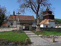 Église du village
 République tchèque
 Semanín


