Ladmovce

Ladmovce
Ladmovce
(Village)
Administration
Pays Drapeau de Slovaquie Slovaquie
Région Région de Košice
District District de Trebišov
Code postal 076 34
Plaque minéralogique TV
Starosta (maire) Alžbeta Szabová ( SMK-MKP )

Mandat: 2013

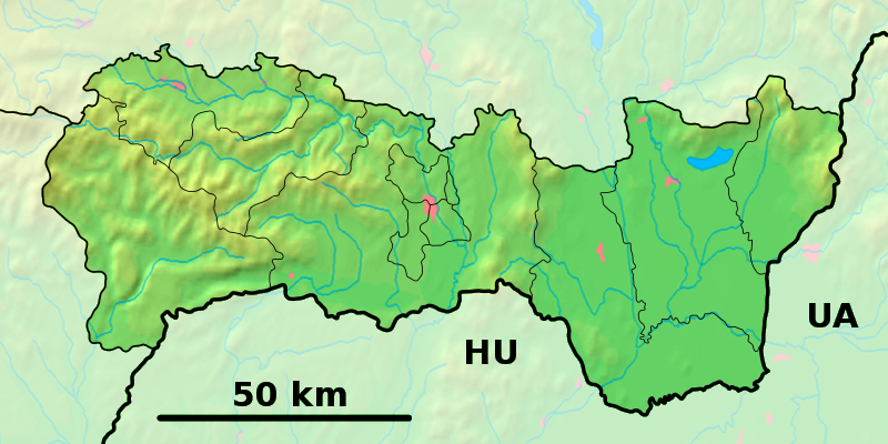
Démographie
Population 340 hab. (31.12.2007)
Densité 30 hab./km2
Géographie
Coordonnées 48° 24′ 44″ Nord
       21° 46′ 50″ Est
/ 48.412222, 21.780556
Altitude 106 m
Superficie 1 132,3 ha = 11,323 km²
Localisation en Slovaquie
Voir la carte physique
Localisation de la ville
Ladmovce
Voir la carte administrative
Localisation de la ville
Ladmovce
Localisation dans la région de Košice
Voir la carte physique
Localisation de la ville
Ladmovce
Voir la carte administrative
Localisation de la ville
Ladmovce
Sources
Resultat des élections
http://www.e-obce.sk [1]
http://www.statistics.sk [2]

Ladmovce est un village de Slovaquie situé dans la région de Košice.

Histoire

Première mention écrite du village en 1298.

La localité fut annexée par la Hongrie après le premier arbitrage de Vienne le 2 novembre 1938. En 1938, on comptait 879 habitants dont 112 d'origines juives. Elle faisait partie du district de Sátoraljaújhely (hongrois : Sátoraljaújhelyi járás). Le nom de la localité avant la Seconde Guerre mondiale était Ladmovce/Ladamóc. Durant la période 1938 -1945, le nom hongrois Ladamóc était d'usage[3]. À la libération, la commune a été réintégré dans la Tchécoslovaquie reconstituée.

Transport

La rivière Bodrog est navigable de manière saisonnière jusqu'à Ladmovce[4].

Notes et références

  1. e-obce.sk
  2. Mestská a obecná štatistika SR
  3. Osudy slovenských Židov
  4. (sk) [PDF] Institute for transport science KTI, « Slovak waterways today » sur www.kti.hu, p. 6. Consulté le 25 février 2010

Wikimedia Foundation. 2010.

Contenu soumis à la licence CC-BY-SA. Source : Article Ladmovce de Wikipédia en français (auteurs)

Игры ⚽ Поможем решить контрольную работу

Regardez d'autres dictionnaires:

  • Ladmovce — ( hu. Ladamóc) is a village and municipality in the Trebišov District in the Košice Region of south eastern Slovakia.HistoryIn historical records the village was first mentioned in 1298.GeographyThe village lies at an altitude of 125 metres and… …   Wikipedia

  • Zemplín (Ort) — Zemplín Wappen Karte …   Deutsch Wikipedia

  • Trebišov District —   District   Country Slovakia Region …   Wikipedia

  • Bodrog — 48° 27′ 17″ N 21° 49′ 10″ E / 48.4546, 21.8195 …   Wikipédia en Français

  • District de Trebišov — Trebišov Informations Pays …   Wikipédia en Français

  • Košice Region — Geobox | Region name = Košice other name = category = Region image caption = image caption = symbol = symbol type = Coat of arms etymology = official name = motto = nickname = country = Slovakia country state = region = district = commune =… …   Wikipedia

  • Dargov — Coordinates: 48°44′N 21°35′E / 48.733°N 21.583°E / 48.733; 21.583 …   Wikipedia

  • List of municipalities and towns in Slovakia — Slovakia This is a comprehensive list of municipalities and towns in Slovakia. For lists of towns and municipalities sorted by Regions see the individual articles on Regions. For an outdated list of towns only in Slovakia see also List of towns… …   Wikipedia

  • Cejkov — Location of Trebišov District in the Region Cejkov (Hungarian: Céke) is a village and municipality in the Trebišov District in the Košice Region of eastern Slovakia. Con …   Wikipedia

  • Zemplínske Jastrabie — Location of Trebišov District in the Region Zemplínske Jastrabie (Hungarian: Magyarsas) is a village and municipality in the Trebišov District in the Košice Region of eastern Slovakia …   Wikipedia

Share the article and excerpts

Direct link
Do a right-click on the link above
and select “Copy Link”