Illschwang
- Illschwang
-
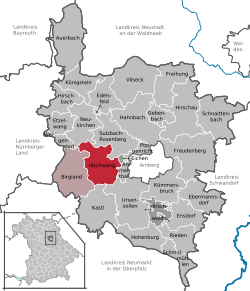
Illschwang est une commune de Bavière (Allemagne), située dans l'arrondissement d'Amberg-Sulzbach, dans le district du Haut-Palatinat, à 10 km au sud de Sulzbach-Rosenberg et à 15 km à l'ouest d'Amberg.
La commune est née en 1978 de la réunion de 32 villages et hameaux. Elle est le siège de la communauté administrative d'Illschwang regroupant les communes d'Illschwang et Birgland et comptant 3 903 habitants en 2006.

Situation de la commune d'
Illschwang dans l'
arrondissement d'
Amberg-
Sulzbach
Sur les autres projets Wikimedia :
Wikimedia Foundation.
2010.
Contenu soumis à la licence CC-BY-SA. Source : Article Illschwang de Wikipédia en français (auteurs)
Regardez d'autres dictionnaires:
Illschwang — Wappen Deutschlandkarte … Deutsch Wikipedia
Illschwang — Infobox German Location Wappen = Wappen Illschwang.png Wappengröße = 114 lat deg = 49 |lat min = 27 lon deg = 11 |lon min = 41 Lageplan = Bundesland = Bayern Regierungsbezirk = Oberpfalz Landkreis = Amberg Sulzbach Verwaltungsgemeinschaft =… … Wikipedia
Illschwang — Original name in latin Illschwang Name in other language State code DE Continent/City Europe/Berlin longitude 49.45 latitude 11.68333 altitude 488 Population 2091 Date 2011 07 31 … Cities with a population over 1000 database
Propstei Illschwang — Die Propstei Illschwang war eine Propstei des Benediktinerordens in Illschwang bei Amberg in der Oberpfalz (Bistum Eichstätt). Illschwang mit der ab dem 12. Jahrhundert erbauten Propsteikirche St. Veit (heute Simultankirche) Geschichte … Deutsch Wikipedia
Verwaltungsgemeinschaft Illschwang — Wappen Deutschlandkarte Hilfe zu Wappen … Deutsch Wikipedia
Liste der Orte im Landkreis Amberg-Sulzbach — Die Liste der Orte im Landkreis Amberg Sulzbach listet die 614 amtlich benannten Gemeindeteile (Hauptorte, Kirchdörfer, Pfarrdörfer, Dörfer, Weiler und Einöden) im Landkreis Amberg Sulzbach auf.[1] Systematische Liste Alphabet der Städte und… … Deutsch Wikipedia
Fürnried — Wappen Deutschlandkarte … Deutsch Wikipedia
Amberg-Sulzbach — Wappen Deutschlandkarte … Deutsch Wikipedia
Birgland — Wappen Deutschlandkarte … Deutsch Wikipedia
Landkreis Amberg-Sulzbach — Wappen Deutschlandkarte … Deutsch Wikipedia
 Allemagne
 Bavière


