- Freihung
-
Freihung 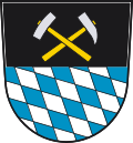
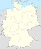

Administration Toponyme officiel Pays  Allemagne
Land  Bavière
District
(Regierungsbezirk)Haut-Palatinat Arrondissement
(Landkreis)Arrondissement d'Amberg-Sulzbach Code communal
(Gemeindeschlüssel)09 3 71 121 Code postal 92 271 Indicatif téléphonique 09 646, 09 622 Immatriculation AS Site web http://www.markt-freihung.de Politique Bourgmestre
(Bürgermeister)Norbert Bücherl Partis au pouvoir FW Géographie Coordonnées Altitude (NN) 433 m Superficie 46,34 km2 Démographie Population 2 542 hab. (2009) Densité 55 hab./km2 modifier 
Freihung est une ville de Bavière (Allemagne), située dans l'arrondissement d'Amberg-Sulzbach, dans le district du Haut-Palatinat.
Personnalité
Liens externes
Catégorie :- Ville de Bavière


Wikimedia Foundation. 2010.