Batlow
Contenu soumis à la licence CC-BY-SA. Source : Article Batlow de Wikipédia en français (auteurs)
Regardez d'autres dictionnaires:
Batlow — /ˈbætloʊ/ (say batloh) noun a town in the shire of Tumut in NSW; fruit growing. The Batlow area lies in territory traditionally inhabited by the Ngarigo people. In 1853 an alluvial goldfield was discovered here and the town, known first as Reedy… …
Batlow, New South Wales — Infobox Australian Place | type = town name = Batlow state = nsw caption = Entering Balow lga = Tumut Shire postcode = 2730 pop = 1,369 (2001) elevation= 725 est = 1850s county = Wynyard stategov = Wagga Wagga fedgov = Eden Monaro dist1 = 438… … Wikipedia
Tumut and Kunama railway lines, New South Wales — The Tumut and Kunama railway lines are disused railway lines in the south of New South Wales, Australia. The Tumut line was a 104 km long branch of the Main South line, branching southwards from it at Cootamundra and heading to the town of Tumut … Wikipedia
Main Southern railway line, New South Wales — [v · New Binalong station on 1916 alignment Gauge: 1,435 mm (4 ft 8 1 … Wikipedia
Sam Hughes (artist) — Sam Hughes (born 4 November 1977 ) is an Australian painter.Hughes was born in Laverton, Victoria and raised in the Blue Mountains, New South Wales. He developed an early interest in visual arts, and then went on to become a jeweller in Sydney.… … Wikipedia
Wondalga, New South Wales — Infobox Australian Place | type = town name = Wondalga state = nsw caption = Wondalga lga = postcode = 2729 pop = 361 (within 7 km radius) est = elevation= 361 maxtemp = mintemp = rainfall = county = Wynyard stategov = Wagga Wagga fedgov = dist1 … Wikipedia
Laurel Hill, New South Wales — Infobox Australian Place | type = town name = Laurel Hill state = nsw caption = Laurel Hill lga = Tumbarumba Shire Council postcode = 2649 coordinates = coord|35|36|1|S|148|5|35|E |scale:100000 region:AU NSW |display=title,inline pop = 165… … Wikipedia
Wynyard County — Map of all coordinates from Google Map of all coordinates from Bing Export all coordinates as KML … Wikipedia
List of Government schools in New South Wales: A–F — The New South Wales Department of Education and Training (DET) is a department of the Government of New South Wales. In addition to other responsibilities, it operates primary schools and secondary schools throughout the state. Contents 1 A 2 B 3 … Wikipedia
Cocoparra National Park — IUCN Category II (National Park) … Wikipedia
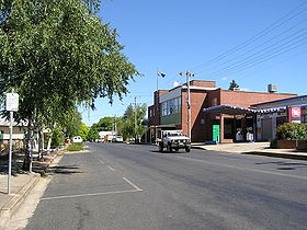
 La grand rue de Batlow
 Australie

