Aonach Beag
- Aonach Beag
-
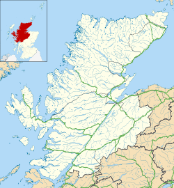
L'Aonach Beag est une montagne du Royaume-Uni située en Écosse, dans les monts Grampians, à trois kilomètres à vol d'oiseau à l'est du Ben Nevis.
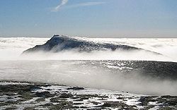
La montagne a la particularité de présenter sur sa face nord un des rares névés permanents d'Écosse. Il se trouve dans une combe à une altitude d'environ 950 mètres.
Un des moyens d'accéder au sommet est d'emprunter le télécabine de la station de sports d'hiver de l'Aonach Mòr jusqu'à une altitude de 650 mètres, de gravir l'Aonach Mòr puis de suivre l'arête reliant les deux sommets pour arriver à l'Aonach Beag.
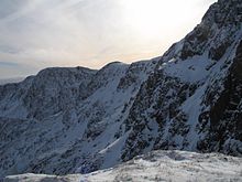
Vue d'
An Aghaidh Gharbh,
la face est du Aonach Beag située juste sous le sommet (
non visible sur la droite).
Lien externe
Sur les autres projets Wikimedia :
Wikimedia Foundation.
2010.
Contenu soumis à la licence CC-BY-SA. Source : Article Aonach Beag de Wikipédia en français (auteurs)
Regardez d'autres dictionnaires:
Aonach Beag — Infobox Mountain Name = Aonach Beag Photo = Aonach beag.jpg Caption = Aonach Beag from Aonach Mòr Elevation = 1234 m (4049 ft) Location = Lochaber, Scotland Range = Prominence = 404 m Parent peak = Ben Nevis Topographic OS Landranger 41 Grid ref… … Wikipedia
Aonach Mòr — Nevis range redirects here. Nevis range can also be used to refer to the range of mountains around Ben Nevis, at the western end of the Grampians. Aonach Mòr Distant shot of Aonach Mòr from Banavie … Wikipedia
Aonach Mòr — Ne doit pas être confondu avec Aonach Beag. Aonach Mòr Vue de l Aonach Mòr enneigé. Géographie … Wikipédia en Français
Aonach Eagach — Sgor nam Fiannaidh The Aonach Eagach above the A82, looking up Glen Coe Elevation 967 m (3,173 ft) … Wikipedia
List of Munros — Infobox Mountain Name = Sections of Munro s tables Photo = Scotland sections of Munro s tables.png Caption = The approximate divisions of Scotland used in Munro s tables Elevation = over 3,000 feet (914.4 metres) Location = SCO Range = Prominence … Wikipedia
Mamores — The Mamores are a group of mountains in the Lochaber area of the Grampian Mountains in the Scottish Highlands. They form an east west ridge approximately fifteen kilometres in length lying between Glen Nevis to the north and Loch Leven to the… … Wikipedia
Càrn Mòr Dearg — Càrn Mòr Dearg: seen from Ben Nevis Elevation 1,223 m (4,012 ft) … Wikipedia
Mullach nan Coirean — seen from Stob Bàn across Coire Dearg. Elevation … Wikipedia
Chno Dearg — seen from Stob Coire Sgriodain, two km to the west. Elevation … Wikipedia
Ben Nevis — Infobox Mountain Name = Ben Nevis Photo = BenNevis2005.jpg Photo size = 300px Caption = Ben Nevis from Banavie. The summit is beyond and to the left of the apparent highest point. Location = Lochaber, flag|Scotland Elevation = convert|1344|m|ft|0 … Wikipedia
 Royaume-Uni
 Écosse