Tofua

Tofua
Tofua
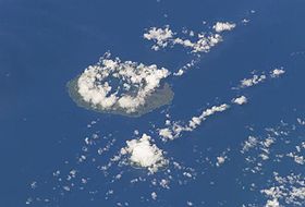
Image satellite de Tofua (au centre) et de Kao (en bas).
Géographie
Pays Drapeau de Tonga Tonga
Archipel Ha'apai (Tonga)
Localisation Océan Pacifique
Coordonnées 19° 45′ S 175° 04′ W / -19.75, -175.0719° 45′ S 175° 04′ W / -19.75, -175.07
Superficie 55,63 km2
Point culminant non nommé (515 m)
Géologie
Géologie Île volcanique
Type Volcan gris
Activité Actif
Dernière éruption 13 juillet 2011
Code [1] 0403-06=
Administration
Drapeau de Tonga Tonga
Division Ha'apai
Démographie
Population 5 hab. (1996)
Densité 0,09 hab./km2
Autres informations
Découverte Préhistoire
Fuseau horaire UTC+13

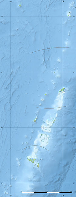
Géolocalisation sur la carte : Tonga

(Voir situation sur carte : Tonga)
Tofua
Tofua
Îles des Tonga

Tofua, aussi appelée Amatofua et Tofooa, est une île volcanique des Tonga, dans les îles Ha'apai.

Géographie

D'une superficie de 55,63 km2, l'île est circulaire et comporte en son centre un lac de plus de 8 km2 de superficie logé dans le fond d'une caldeira. Cette caldeira est encore active via le Lofia, un cône volcanique à situé l'intérieur de la dépression.

Le kava est cultivé sur l'île par ses cinq habitants qui exportent la production à Tongatapu.

Histoire

Xavier Rosset, ancien snowboarder et aventurier suisse séjourne sur l'île durant 300 jours du 15 septembre 2008 au 30 juin 2009, équipé uniquement d'un couteau suisse, d'une machette, d'un hameçon et d'un fil de pêche, d'une caméra rechargeable par panneau solaire afin de filmer son aventure.


Wikimedia Foundation. 2010.

Contenu soumis à la licence CC-BY-SA. Source : Article Tofua de Wikipédia en français (auteurs)

Игры ⚽ Нужна курсовая?

Regardez d'autres dictionnaires:

  • Tofua — NASA Satellitenbild (Geocover 2000) Tofua ist die größere Insel Im Nordosten liegt Kao …   Deutsch Wikipedia

  • Tofua — Caldera, in Tonga, is the summit caldera of a steep sided composite cone that forms Tofua Island. Pre caldera activity is recorded by a sequence of pyroclastic deposits and lavas constituting the older cone, followed on the northern part of the… …   Wikipedia

  • Tofua — Vista de satélite de la isla Tofua (izquierda) y la isla Kao (derecha) en Tonga …   Wikipedia Español

  • Tofua — (Tofoa, Ammatofua), Insel aus der Kottugruppe des Tonga Archipels …   Pierer's Universal-Lexikon

  • Mutiny on the Bounty — For other uses, see Mutiny on the Bounty (disambiguation). The mutineers turning Lt Bligh and some of the officers and crew adrift from His Majesty s Ship Bounty, 29 April 1789. By Robert Dodd The mutiny on the Bounty was a mutiny that occurred… …   Wikipedia

  • Kao (Insel) — Kao NASA Satellitenbild (Geocover 2000) Kao ist die kleinere Insel südwestlich davon liegt Tofua …   Deutsch Wikipedia

  • William Bligh — Infobox Person name = William Bligh image size = 240px caption = 1814 portrait birth name = birth date = birth date|1754|09|09|df=y birth place = St Tudy, Cornwall, United Kingdom death date = death date and age|1817|12|7|1754|09|09|df=y death… …   Wikipedia

  • Bounty (Schiff und Meuterei) — Bounty Bligh und die loyal gebliebenen Seeleute verlassen die HMS Bounty Schiffsdaten Name: HMAV Bounty (oder HMS Bounty), bis 8. Juni 1787 Bethia Baujahr: 1784, Umbau 1787 Werft: Hull (England) Besatzung: 44 Mann (siehe Artikel) …   Deutsch Wikipedia

  • Freundschaftsinseln — Puleʻanga Fakatuʻi ʻo Tonga (tongaisch) Kingdom of Tonga (englisch) Königreich Tonga …   Deutsch Wikipedia

  • HMS Bounty — Bounty Bligh und die loyal gebliebenen Seeleute verlassen die HMS Bounty Schiffsdaten Name: HMAV Bounty (oder HMS Bounty), bis 8. Juni 1787 Bethia Baujahr: 1784, Umbau 1787 Werft: Hull (England) Besatzung: 44 Mann (siehe Artikel) …   Deutsch Wikipedia

Share the article and excerpts

Direct link
Do a right-click on the link above
and select “Copy Link”