Ŏtdâr Méanchey
- Ŏtdâr Méanchey
-
Otdar Mean Cheay
|
|
| Pays |
 Cambodge Cambodge |
| Capitale |
Phumi Samraong |
| Superficie |
6 158 km² |
| Population |
68 279 (1998) |
| Densité |
11,1 hab./km² |
| ISO 3166-2 |
KH-22 |
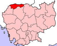 |
Otdar Mean Cheay ("Nord victorieux" en khmer, otdar dérive du sanskrit uttarā : "septentrional" et chey de jaya : "victoire") est une province du Cambodge. Elle comprend 5 districts :
Bibliographie
- Lewitz, S., La toponymie khmère, BEFEO (Bulletin de l'École française d'Extrême-Orient) 53, 2, 1967, pp. 377-450.
- Lewitz, S., Martel, G. et Vidal, J.-E., Notes ethnobotaniques sur quelques plantes en usage au Cambodge, BEFEO 55, 1969, pp. 171-232.
- Lewitz, S. et Rollet, B., Lexique des noms d’arbres et d’arbustes au Cambodge, BEFEO 60, 1973, pp. 113-162.
- Pou, S., Dictionnaire vieux khmer-français-anglais. An Old Khmer-French-English Dictionary, L'Harmattan, 2004, 2e édition augmentée, 732 p.
 Portail du Cambodge
Catégorie : Province du Cambodge
Wikimedia Foundation.
2010.
Contenu soumis à la licence CC-BY-SA. Source : Article Ŏtdâr Méanchey de Wikipédia en français (auteurs)
Regardez d'autres dictionnaires:
Oddar Meanchey — Otdar Mean Cheay Otdar Mean Cheay Pays … Wikipédia en Français
Province d'Otdar Mean Cheay — 14° 10′ 00″ N 103° 30′ 00″ E / 14.16666667, 103.5 … Wikipédia en Français
Bântéay Méanchey — Banteay Mean Chey បន្ទាយមានជ Banteay Mean Chey Pays … Wikipédia en Français
Military history of Cambodia — History attests to Cambodia s martial origins. In antiquity Cambodia, having conquered Laos, parts of Thailand, and the Malay Peninsula, held sway over a vast area of Southeast Asia. Khmer martial prowess waned in the early 15th century, however … Wikipedia
ISO 3166-2:KH — ISO 3166 2 – données pour le Cambodge. Sommaire 1 Mise à jour 2 Municipalités autonomes (4) en:autonomous municipality, km:krong (GDOCM) / krŏng (BGN/PCGN) 3 Provinces (20) km:kh … Wikipédia en Français
Iso 3166-2:kh — ISO 3166 2 – données pour le Cambodge. Sommaire 1 Mise à jour 2 Municipalités autonomes (4) en:autonomous municipality, km:krong (GDOCM) / krŏng (BGN/PCGN) 3 Provinces ( … Wikipédia en Français
Καμπότζη — Επίσημη ονομασία: Βασίλειο της Καμπότζης Έκταση: 181.040 τ. χλμ. Πληθυσμός: 12.775.324 (2002) Πρωτεύουσα: Πνομ Πενχ (999.804 κάτ. το 1998)Κράτος της νοτιοανατολικής Ασίας, στη χερσόνησο της Ινδοκίνας. Συνορεύει στα Δ και στα ΒΔ με την Ταϊλάνδη,… … Dictionary of Greek
Kampuchean People's Revolutionary Armed Forces — The Kampuchean People s Revolutionary Armed Forces (KPRAF) was the formal title given to the armed forces People s Republic of Kampuchea, the de facto government of Cambodia 1979 1990. The KPRAF was formed initially from militias, former Khmer… … Wikipedia
Province de Banteay Mean Chey — 13° 45′ N 103° 00′ E / 13.75, 103 … Wikipédia en Français
Liste des districts du Cambodge — Voici la liste des 171 districts du Cambodge (srŏk) ainsi que 15 quartiers (khan), classés par province. Chaque district possède un code ISO 3166 2:KH, les deux premiers chiffres indiquent la province tandis que les deux derniers le district.… … Wikipédia en Français