Wonseradeel
- Wonseradeel
-
Wûnseradiel
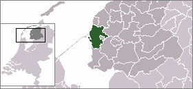
Wûnseradiel (en néerlandais, Wonseradeel), est une commune néerlandaise de la Frise.
Localités
Le village de Makkum est connu pour sa poterie en grès.
Personnalités liées à la commune
Le poète Obe Postma est né dans la commune, au village de Cornwerd.
Lien externe
(fy)(nl) Site officiel
 Portail des Pays-Bas
Catégorie : Commune de la Frise
Wikimedia Foundation.
2010.
Contenu soumis à la licence CC-BY-SA. Source : Article Wonseradeel de Wikipédia en français (auteurs)
Regardez d'autres dictionnaires:
Wonseradeel — Gemeinde Wûnseradiel Flagge Wappen Provinz Friesland Bürgermeister Theunis Piersma … Deutsch Wikipedia
Wûnseradiel — Infobox City official name = Wûnseradiel other name = Wonseradeel mapsize = 280px subdivision type = Country subdivision name = Netherlands subdivision type1 = Province subdivision name1 = Fryslân area footnotes = (2006) area total km2 = 317.68… … Wikipedia
Wunseradiel — Wûnseradiel Wûnseradiel … Wikipédia en Français
Liste aller niederländischen Gemeinden M–Z — In diese Liste werden alle Gemeinden, die auf dem Gebiet der jetzigen Niederlande bestehen oder bestanden haben, aufgenommen. Die Liste beginnt im Jahr 1805/10. Vor 1830 können die Angaben unvollständig sein. Kleinere Grenzkorrekturen oder… … Deutsch Wikipedia
Wûnseradiel — Gemeinde Wûnseradiel Flagge Wappen Provinz Friesland … Deutsch Wikipedia
Pier Gerlofs Donia — Etching of Grutte Pier, from Chronycke ofte Historische Geschiedenis van Frieslant published in 1622.[1] … Wikipedia
Kornwerderzand — Infobox Settlement official name = Kornwerderzand mapsize = subdivision type = Country subdivision name = flagicon|Netherlands Netherlands subdivision type1 = Province subdivision name1 = flagicon|Friesland Friesland settlement type = population… … Wikipedia
Arum, Friesland — Arum Village … Wikipedia
Gale Hania — ( 1380) was the thirteenth potestaat (or ruler) of Friesland, a province of Netherlands.BiographyHis name is also known written as Hanja or Hanya. Gale was born on the Hanya farm northeast of Pingjum, in the shire of Wonseradeel. The path… … Wikipedia
Grietenij — A grietenij was a forerunner to the gemeente or municipality in Frisia, particularly in Friesland, and also in Groningen which are now a part of the Netherlands. From the end of the 16th century until 1851, there were a total of 30 Grietenijen in … Wikipedia


