Tabuaeran

Tabuaeran
Page d'aide sur l'homonymie Pour les articles homonymes, voir Fanning (homonymie).
Tabuaeran
Fanning Island (en)
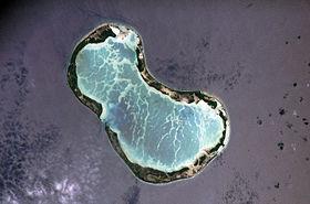
Image satellite de Tabuaeran.
Géographie
Pays Drapeau des Kiribati Kiribati
Archipel Îles de la Ligne
Localisation Océan Pacifique
Coordonnées 3° 51′ 36″ N 159° 21′ 52″ W / 3.86, -159.3644443° 51′ 36″ N 159° 21′ 52″ W / 3.86, -159.364444
Superficie 33,7 km2
Nombre d'îles plus de 12
Île(s) principale(s) Motu o Tau
Point culminant non nommé (4 m)
Géologie Atoll
Administration
Drapeau des Kiribati Kiribati
Aucun découpage territorial -
Démographie
Population 2 539 hab. (2005)
Densité 75,34 hab./km2
Autres informations
Fuseau horaire UTC+14

Géolocalisation sur la carte : Kiribati

(Voir situation sur carte : Kiribati)
Tabuaeran
Tabuaeran
Archipels des Kiribati

Tabuaeran ou île Fanning, en anglais Fanning Island, est un atoll des îles de la Ligne, appartenant à la république des Kiribati.

Sa population est de 2 539 habitants en 2005, en forte augmentation en raison notamment de l'industrie touristique, de développement récent et de la politique de repeuplement des Kiribati. Un navire de croisière de la NCL (Norwegian Cruise Line), le Norwegian Wind dessert l'île chaque semaine, à partir d'Hawaii, de façon à bénéficier du régime de la détaxe.

Sa superficie terrestre est de 33,7 km2 environ, avec un lagon interne. Découverte par l'explorateur américain Edmund Fanning en 1798 (d'où son nom), elle n'a pris son nom actuel (d'origine polynésienne) que lors de l'indépendance en 1979. Annexée par le Royaume-Uni en 1889, elle fit partie de la colonie des îles Gilbert et Ellice dès 1916. Célèbre pour une station du câble télégraphique transocéanique.

Le coprah est la seule exportation (avec un peu d'algues).

Liens externes

Sur les autres projets Wikimedia :


Wikimedia Foundation. 2010.

Contenu soumis à la licence CC-BY-SA. Source : Article Tabuaeran de Wikipédia en français (auteurs)

Игры ⚽ Поможем написать курсовую

Regardez d'autres dictionnaires:

  • Tabuaeran — Tabuaeran, also known as Fanning Island or Fanning Atoll (both Gilbertese and English names are recognised) is one of the Line Islands of the central Pacific Ocean, and part of Kiribati. It is an atoll located at… …   Wikipedia

  • Tabuaeran — NASA Foto von Tabuaeran Gewässer Pazifischer Ozean Archipel Line Islands …   Deutsch Wikipedia

  • Tabuaeran — Tabuaeran,   früher Fanning Island [ fænɪȖ aɪlənd], Atoll der zu Kiribati gehörenden Linieninseln, im zentralen Pazifik bei 159º 20 westliche Länge und 3º 50 nördliche Breite; die Inseln mit zusammen 35 km2 umgeben eine Lagune von 116 km2; 1 300… …   Universal-Lexikon

  • Tabuaeran — Admin ASC 2 Code Orig. name Tabuaeran Country and Admin Code KI.02.TU KI …   World countries Adminstrative division ASC I-II

  • Tabuaeran Atoll — ▪ atoll, Kiribati formerly called  Fanning Atoll  or  Fanning Island   coral formation of the Northern Line Islands, part of Kiribati, in the west central Pacific Ocean. Discovered in 1798 by an American trader and explorer, Edmund Fanning, the… …   Universalium

  • Tabuaeran — or formerly Fanning Island geographical name island W Pacific in the Line Islands area 15 square miles (39 square kilometers), population 376 …   New Collegiate Dictionary

  • Tabuaeran — Tabueran, también conocido como Isla Fanning, es un atolón de coral del grupo de las islas de la Línea, pertenecientes a la República de Kiribati, en el océano Pacífico central. Tiene una altitud máxima de 3 metros sobre la marea alta. Fue… …   Wikipedia Español

  • Fanning-Insel — Tabuaeran NASA Foto von Tabuaeran Gewässer Pazifischer Ozean Archipel Line Islands …   Deutsch Wikipedia

  • Fanning Island — Tabuaeran NASA Foto von Tabuaeran Gewässer Pazifischer Ozean Archipel Line Islands …   Deutsch Wikipedia

  • Fanninginsel — Tabuaeran NASA Foto von Tabuaeran Gewässer Pazifischer Ozean Archipel Line Islands …   Deutsch Wikipedia

Share the article and excerpts

Direct link
Do a right-click on the link above
and select “Copy Link”