Onotoa
- Onotoa
-
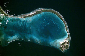
Onotoa est un atoll des Kiribati, dans le sud de l'archipel des îles Gilbert.
Sa superficie est de 13,5 km2 pour une population de 2 043 Gilbertins.
La plupart des historiens considèrent qu'elle a été découverte par le capitaine Clark sur le baleinier britannique John Palmer en 1826. La même année, le capitaine américain Chase l'observa du navire Japan.
Onotoa est située au nord de Tamana et d'Arorae.
Lien externe
Sur les autres projets Wikimedia :
Wikimedia Foundation.
2010.
Contenu soumis à la licence CC-BY-SA. Source : Article Onotoa de Wikipédia en français (auteurs)
Regardez d'autres dictionnaires:
Onotoa — Main articles: Kiribati and Gilbert Islands Onotoa is an atoll and district of Kiribati. It is situated in the Gilbert Islands in the Pacific Ocean, 65 km from Tamana, the smallest island in the Gilberts. The atoll is similar to many other atolls … Wikipedia
Onotoa — es un atolón y un distrito de la República de Kiribati en el océano Pacífico, a 65 km de Tamana, la isla más pequeña de las Islas Gilbert. El atolón es similar a muchos otros atolones en las Islas Gilbert, con su línea continua de islotes e islas … Wikipedia Español
Onotoa — Karte der Gilbertinseln, Onotoa im Süden Onotoa ist ein Atoll im pazifischen Archipel der Gilbertinseln und gehört zum Staat Kiribati. Es liegt ca. 65 km nordwestlich von Tamana, der kleinsten Insel des Archipels entfernt. Das Atoll hat… … Deutsch Wikipedia
Onotoa — Admin ASC 2 Code Orig. name Onotoa Country and Admin Code KI.01.ON KI … World countries Adminstrative division ASC I-II
Flugplatz Onotoa — BW … Deutsch Wikipedia
Gilbert-Inseln — Lage der Gilbertinseln im Pazifik Die Gilbertinseln sind eine Kette von 16 Atollen im Pazifik, die zum Inselstaat Kiribati gehören. Das bevölkerungsreichste und bedeutendste Atoll ist Tarawa, auf welchem die Hauptstadt South Tarawa auf der Insel… … Deutsch Wikipedia
KI-G — Lage der Gilbertinseln im Pazifik Die Gilbertinseln sind eine Kette von 16 Atollen im Pazifik, die zum Inselstaat Kiribati gehören. Das bevölkerungsreichste und bedeutendste Atoll ist Tarawa, auf welchem die Hauptstadt South Tarawa auf der Insel… … Deutsch Wikipedia
Gilbert Islands — Gilberts redirects here. For other uses, see Gilberts (disambiguation). The Gilbert Islands (Gilbertese: Tungaru;[1] formerly Kingsmill Islands[2]) are a chain of sixteen atolls and coral islands in the Pacific Ocean. They are the main part of… … Wikipedia
4A — Air Kiribati IATA Cod … Deutsch Wikipedia
Flughafen Bonriki — Bonriki International Airport … Deutsch Wikipedia
 Kiribati
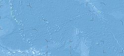
 Onotoa