- Rothorn de Zinal
-
Zinalrothorn
Zinalrothorn 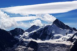
Le Zinalrothorn vu du nord-ouestGéographie Altitude 4 221 m Massif Alpes valaisannes Longueur km Largeur km Superficie km2 Coordonnées Administration Pays  Suisse
Canton Valais Districts Sierre, Viège Ascension Première 22 août 1864, Leslie Stephen, Florence Crauford Grove, Melchior et Jakob Anderegg Voie la plus facile Arête Sud-Est, depuis le refuge du Rothorn Géologie Âge Roches Géolocalisation sur la carte : Suisse 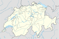

modifier 
Le Zinalrothorn (4 221 mètres) est un sommet des Alpes valaisannes près de Zermatt.
Du sommet, la vue vers le Cervin et le mont Rose est fantastique.
Sommaire
Ascensions
La première ascension a été réalisée par Leslie Stephen et Florence Crauford Grove accompagnés des guides Melchior et Jakob Anderegg depuis Zinal par le versant Nord (ZS, III) le 22 août 1864.
Accès
- Départ : refuge du Rothorn (3 198 m). Depuis Zermatt, 1 600 m de dénivelée en passant par les gorges du Triftbach.
- Difficulté : AD, passages de III.
Annexes
Articles connexes
Liens externes
 Portail de la montagne
 Portail du Valais
Catégories : Sommet des Alpes suisses | Alpes valaisannes | Montagne du canton du Valais | Sommet de plus de 4 000 mètres des Alpes


Wikimedia Foundation. 2010.