- Amol
-
Amol
(fa) آمل
Administration Pays  Iran
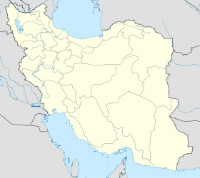
IranProvince Mazandaran Indicatif téléphonique international +(98) Géographie Coordonnées Altitude 94 m Superficie 2 100 ha = 21 km2 Démographie Population 202 518 hab. (2005) Densité 9 643,7 hab./km2 Localisation Sources World Gazetteer Index Mundi Amol (en Persan: آمل) est une ville au nord de l'Iran, dans la province du Mazandaran. Amol best turism city in iran . Damavand.Lar dam.Oprios in the Amol Damavand,Lar dam in Amol is. Amol amard history iran Traversée par la rivière Haraz, Amol est située à 20 km au sud de la mer Caspienne et à 10 km au nord des monts Alborz. Elle se trouve également à 180 km de Téhéran et à 70 km de Sari, la capitale de la province.
Amol history & Nature
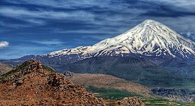
Amol best City iran History ,Nature north of Iran. Mont Damavand ,Barrage de Lar, Lar lake ,Davazdah Cheshme Bridge in Amol city.
Modern Āmol
Modem Āmol is a typical Caspian city and thus atypical of many other Iranian cities, especially with regard to its urban structures and architecture. Nineteenth-century travelers describe it like many other towns of the Caspian lowlands, as “so overgrown with jungle and orchards as to be collectively invisible” (G. N. Curzon, Persia and the Persian Question I, London, 1892, p. 382). At the same time, the natural protection of surrounding forests (as well as the absence of nomads in recent times) meant that these towns had no need for the surrounding walls, gates, and other fortifications characteristic of most traditional cities of central Iran. The abundance of forests also accounts for a third peculiarity: frequent use of wood as a building material, a practice that led to destructive fires again and again. In addition, devastating epidemics, mainly due to the unhealthy climate and bad hygienic conditions caused heavy population losses in Āmol and other Caspian cities. Toward the beginning of the 19th century J. B. Fraser described Āmol as almost depopulated because of epidemics and Turkmen raids (A Winter’s Journey from Constantinople to Tehran with Travels through Various Parts of Persia II, London, 1838, pp. 453-54). By the end of the century, the population of the town was estimated at 8,000 (Curzon, op. cit.). At the beginning of this century, H. L. Rabino described Āmol as an open town with four gates, nine quarters, and approximately 2000 houses. A large bazaar contained about 400 shops with many traditional crafts and trades (“A Journey in Mazanderan from Resht to Sari,” Geographical Journal 42, 1913, pp. 446-47). Although today Āmol has expanded greatly on both sides of the Harāz river, its functions are still the same as they were seventy or eighty years ago. Besides being one of the šahrestān centers of the province of Māzandarān, it is a busy commercial center; its location at the end of the Harāz road, one of the main connections between the Caspian lowland and Tehran, gives it important traffic functions. Since it is one of the urban centers of the rich rice-growing region of central Māzandarān, the marketing, processing, purchase, and sale of rice is of special importance to the urban economy; many of the urban notables have always been in this business. Industrially Āmol is awaiting development. The once famous ironworks of the region, with their charcoal-fired foundries along the Harāz river, no longer exist (cf. M. Trezel, “Notice géographique et statistique sur le Ghilan et le Mazanderan, provinces de l’Empire de Perse,” Journal des sciences militaires des armées de terre et de mer 2, 1826, pp. 110-23, 512-26). In the 19th century, Āmol iron and iron goods were traded all over Iran and as far abroad as Baghdad and Damascus. Today, the main industries are small food-processing factories (rice), minor woodworking shops, and a few brickworks, almost none of which employ more than two or three people. The population has recently grown from approximately 22,000 (1956) to 40,076 (1966) and 68,782 (1976). The present size of the city, which is comparable to that of Bābol, Sārī, and Šāhī, places the urban structure of Māzandarān in striking contrast to that of neighboring Gīlān, where Rašt is the only and undisputed center.
Histoire de l'Iran - Civilisation proto-élamite (3200 – 2700 av. J.-C.)
- Royaume élamite (2700 – 539 av. J.-C.)
- Royaume mède (728 – 550 av. J.-C.)
- Dynastie achéménide (648 – 330 av. J.-C.)
- Empire séleucide (330 – 150 av. J.-C.)
- Empire parthe (250 av. J.-C. – 226)
- Dynastie sassanide (226 – 650)
- Conquête islamique (637 – 651)
- Dynastie samanide (875 – 999)
- Dynastie ziyaride (928 – 1043)
- Dynastie bouyide (934 – 1055)
- Dynastie ghaznévide (963 – 1187)
- Empire turc seldjoukide (1037 – 1194)
- Empire khorezmien (1077 – 1231)
- Dynastie ilkhanide (1256 – 1353)
- Dynastie muzaffaride (1314 – 1393)
- Dynastie timouride (1370 – 1506)
- Dynastie séfévide (1501 – 1722/1736)
- Afghans hotaki (1722 – 1729)
- Dynastie afsharide (1736 – 1802)
- Dynastie Zand (1750 – 1794)
- Dynastie kadjar (1781 – 1925)
- Dynastie Pahlavi (1925 – 1979)
- Révolution iranienne (1979)
- Gouvernement provisoire (1979 – 1980)
- Rép. islamique d'Iran (1980 – maintenant)
bl:imol
Catégories :- Histoire de l'Iran
- Ville d'Iran
Wikimedia Foundation. 2010.


